You are here: Home > Network List > AG - Arkansas Seismic Network Stations List
> Station WHAR Woolly Hollow State Park,AR > Earthquake Result Viewer
WHAR Woolly Hollow State Park,AR - Earthquake Result Viewer
| Earthquake location: |
Near Coast Of Ecuador |
| Earthquake latitude/longitude: |
0.4/-79.8 |
| Earthquake time(UTC): |
2016/05/18 (139) 07:57:05 GMT |
| Earthquake Depth: |
32 km |
| Earthquake Magnitude: |
6.7 MWP, 6.7 MWW, 6.7 MI |
| Earthquake Catalog/Contributor: |
NEIC PDE/NEIC COMCAT |
|
| Network: |
AG Arkansas Seismic Network |
| Station: |
WHAR Woolly Hollow State Park,AR |
| Lat/Lon: |
35.29 N/92.29 W |
| Elevation: |
184 m |
|
| Distance: |
36.6 deg |
| Az: |
342.69 deg |
| Baz: |
158.672 deg |
| Ray Param: |
0.0765342 |
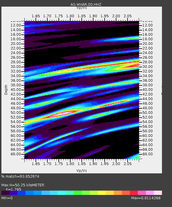
| Estimated Moho Depth: |
50.25 km |
| Estimated Crust Vp/Vs: |
1.76 |
| Assumed Crust Vp: |
6.498 km/s |
| Estimated Crust Vs: |
3.681 km/s |
| Estimated Crust Poisson's Ratio: |
0.26 |
|
| Radial Match: |
93.852974 % |
| Radial Bump: |
356 |
| Transverse Match: |
82.765274 % |
| Transverse Bump: |
400 |
| SOD ConfigId: |
1475611 |
| Insert Time: |
2016-06-01 07:57:36.249 +0000 |
| GWidth: |
2.5 |
| Max Bumps: |
400 |
| Tol: |
0.001 |
|

Signal To Noise
| Channel | StoN | STA | LTA |
| AG:WHAR:00:HHZ:20160518T08:03:37.660005Z | 17.034714 | 2.0960542E-6 | 1.2304605E-7 |
| AG:WHAR:00:HHN:20160518T08:03:37.660005Z | 11.297057 | 1.381342E-6 | 1.222745E-7 |
| AG:WHAR:00:HHE:20160518T08:03:37.660005Z | 7.083186 | 6.741503E-7 | 9.5176134E-8 |
| Arrivals |
| Ps | 6.4 SECOND |
| PpPs | 20 SECOND |
| PsPs/PpSs | 26 SECOND |


