You are here: Home > Network List > TA - USArray Transportable Network (new EarthScope stations) Stations List
> Station A21K Barrow, AK, USA > Earthquake Result Viewer
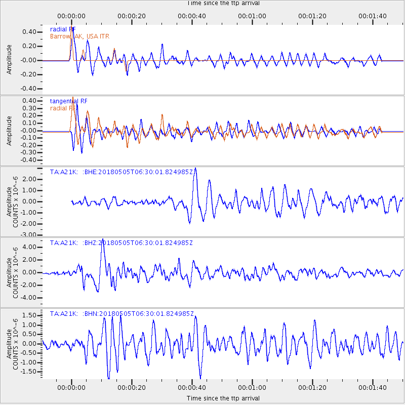
A21K Barrow, AK, USA - Earthquake Result Viewer

| Earthquake location: |
Luzon, Philippines |
| Earthquake latitude/longitude: |
14.5/123.9 |
| Earthquake time(UTC): |
2018/05/05 (125) 06:19:04 GMT |
| Earthquake Depth: |
18 km |
| Earthquake Magnitude: |
6.1 Mww |
| Earthquake Catalog/Contributor: |
NEIC PDE/us |
|
| Network: |
TA USArray Transportable Network (new EarthScope stations) |
| Station: |
A21K Barrow, AK, USA |
| Lat/Lon: |
71.32 N/156.62 W |
| Elevation: |
577 m |
|
| Distance: |
73.0 deg |
| Az: |
19.344 deg |
| Baz: |
264.737 deg |
| Ray Param: |
0.053286318 |
| Estimated Moho Depth: |
38.25 km |
| Estimated Crust Vp/Vs: |
1.82 |
| Assumed Crust Vp: |
6.048 km/s |
| Estimated Crust Vs: |
3.332 km/s |
| Estimated Crust Poisson's Ratio: |
0.28 |
|
| Radial Match: |
91.04397 % |
| Radial Bump: |
400 |
| Transverse Match: |
89.27687 % |
| Transverse Bump: |
331 |
| SOD ConfigId: |
13570011 |
| Insert Time: |
2019-04-30 05:12:34.736 +0000 |
| GWidth: |
2.5 |
| Max Bumps: |
400 |
| Tol: |
0.001 |
|
Signal To Noise
| Channel | StoN | STA | LTA |
| TA:A21K: :BHZ:20180505T06:30:01.824985Z | 6.5153627 | 9.3929634E-7 | 1.4416639E-7 |
| TA:A21K: :BHN:20180505T06:30:01.824985Z | 1.4374471 | 2.7124565E-7 | 1.8869959E-7 |
| TA:A21K: :BHE:20180505T06:30:01.824985Z | 1.5448885 | 3.2293724E-7 | 2.0903595E-7 |
| Arrivals |
| Ps | 5.3 SECOND |
| PpPs | 17 SECOND |
| PsPs/PpSs | 23 SECOND |


