You are here: Home > Network List > TA - USArray Transportable Network (new EarthScope stations) Stations List
> Station C23K Itkillik River, AK, USA > Earthquake Result Viewer
C23K Itkillik River, AK, USA - Earthquake Result Viewer
| Earthquake location: |
Luzon, Philippines |
| Earthquake latitude/longitude: |
14.5/123.9 |
| Earthquake time(UTC): |
2018/05/05 (125) 06:19:04 GMT |
| Earthquake Depth: |
18 km |
| Earthquake Magnitude: |
6.1 Mww |
| Earthquake Catalog/Contributor: |
NEIC PDE/us |
|
| Network: |
TA USArray Transportable Network (new EarthScope stations) |
| Station: |
C23K Itkillik River, AK, USA |
| Lat/Lon: |
69.84 N/150.61 W |
| Elevation: |
179 m |
|
| Distance: |
74.9 deg |
| Az: |
20.975 deg |
| Baz: |
270.848 deg |
| Ray Param: |
0.051984902 |
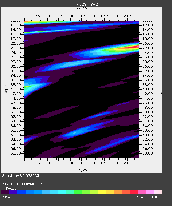
| Estimated Moho Depth: |
10.0 km |
| Estimated Crust Vp/Vs: |
1.60 |
| Assumed Crust Vp: |
6.221 km/s |
| Estimated Crust Vs: |
3.888 km/s |
| Estimated Crust Poisson's Ratio: |
0.18 |
|
| Radial Match: |
82.638535 % |
| Radial Bump: |
400 |
| Transverse Match: |
87.89021 % |
| Transverse Bump: |
393 |
| SOD ConfigId: |
13570011 |
| Insert Time: |
2019-04-30 05:12:43.553 +0000 |
| GWidth: |
2.5 |
| Max Bumps: |
400 |
| Tol: |
0.001 |
|

Signal To Noise
| Channel | StoN | STA | LTA |
| TA:C23K: :BHZ:20180505T06:30:13.199985Z | 3.4202337 | 9.210174E-7 | 2.6928493E-7 |
| TA:C23K: :BHN:20180505T06:30:13.199985Z | 1.2077698 | 2.0664625E-7 | 1.7109738E-7 |
| TA:C23K: :BHE:20180505T06:30:13.199985Z | 1.1831554 | 2.6193766E-7 | 2.2138907E-7 |
| Arrivals |
| Ps | 1.0 SECOND |
| PpPs | 4.0 SECOND |
| PsPs/PpSs | 5.0 SECOND |


