You are here: Home > Network List > TA - USArray Transportable Network (new EarthScope stations) Stations List
> Station C27K Jago River, AK, USA > Earthquake Result Viewer
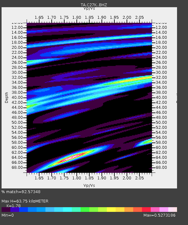
C27K Jago River, AK, USA - Earthquake Result Viewer
| Earthquake location: |
Luzon, Philippines |
| Earthquake latitude/longitude: |
14.5/123.9 |
| Earthquake time(UTC): |
2018/05/05 (125) 06:19:04 GMT |
| Earthquake Depth: |
18 km |
| Earthquake Magnitude: |
6.1 Mww |
| Earthquake Catalog/Contributor: |
NEIC PDE/us |
|
| Network: |
TA USArray Transportable Network (new EarthScope stations) |
| Station: |
C27K Jago River, AK, USA |
| Lat/Lon: |
69.63 N/143.71 W |
| Elevation: |
392 m |
|
| Distance: |
77.3 deg |
| Az: |
21.015 deg |
| Baz: |
277.327 deg |
| Ray Param: |
0.05036984 |
| Estimated Moho Depth: |
63.75 km |
| Estimated Crust Vp/Vs: |
1.78 |
| Assumed Crust Vp: |
6.522 km/s |
| Estimated Crust Vs: |
3.664 km/s |
| Estimated Crust Poisson's Ratio: |
0.27 |
|
| Radial Match: |
92.57348 % |
| Radial Bump: |
400 |
| Transverse Match: |
91.28308 % |
| Transverse Bump: |
400 |
| SOD ConfigId: |
13570011 |
| Insert Time: |
2019-04-30 05:12:44.137 +0000 |
| GWidth: |
2.5 |
| Max Bumps: |
400 |
| Tol: |
0.001 |
|

Signal To Noise
| Channel | StoN | STA | LTA |
| TA:C27K: :BHZ:20180505T06:30:26.899998Z | 9.671724 | 7.5550406E-7 | 7.8114724E-8 |
| TA:C27K: :BHN:20180505T06:30:26.899998Z | 2.3684266 | 1.7922954E-7 | 7.567452E-8 |
| TA:C27K: :BHE:20180505T06:30:26.899998Z | 3.281481 | 2.7596226E-7 | 8.409687E-8 |
| Arrivals |
| Ps | 7.9 SECOND |
| PpPs | 26 SECOND |
| PsPs/PpSs | 34 SECOND |


