You are here: Home > Network List > TA - USArray Transportable Network (new EarthScope stations) Stations List
> Station D17K Noatak River, AK, USA > Earthquake Result Viewer
D17K Noatak River, AK, USA - Earthquake Result Viewer
| Earthquake location: |
Luzon, Philippines |
| Earthquake latitude/longitude: |
14.5/123.9 |
| Earthquake time(UTC): |
2018/05/05 (125) 06:19:04 GMT |
| Earthquake Depth: |
18 km |
| Earthquake Magnitude: |
6.1 Mww |
| Earthquake Catalog/Contributor: |
NEIC PDE/us |
|
| Network: |
TA USArray Transportable Network (new EarthScope stations) |
| Station: |
D17K Noatak River, AK, USA |
| Lat/Lon: |
67.70 N/163.08 W |
| Elevation: |
172 m |
|
| Distance: |
70.2 deg |
| Az: |
22.817 deg |
| Baz: |
259.778 deg |
| Ray Param: |
0.055098884 |
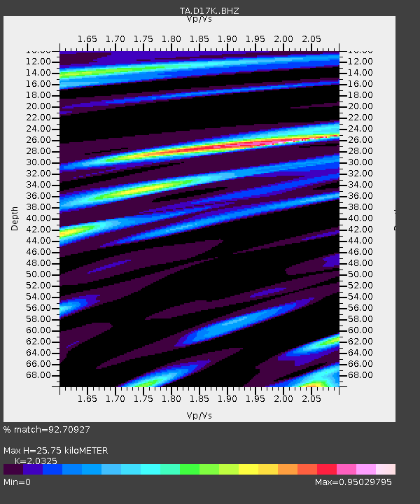
| Estimated Moho Depth: |
25.75 km |
| Estimated Crust Vp/Vs: |
2.03 |
| Assumed Crust Vp: |
6.276 km/s |
| Estimated Crust Vs: |
3.088 km/s |
| Estimated Crust Poisson's Ratio: |
0.34 |
|
| Radial Match: |
92.70927 % |
| Radial Bump: |
265 |
| Transverse Match: |
85.85023 % |
| Transverse Bump: |
390 |
| SOD ConfigId: |
13570011 |
| Insert Time: |
2019-04-30 05:12:46.173 +0000 |
| GWidth: |
2.5 |
| Max Bumps: |
400 |
| Tol: |
0.001 |
|

Signal To Noise
| Channel | StoN | STA | LTA |
| TA:D17K: :BHZ:20180505T06:29:45.324985Z | 5.2433043 | 6.677454E-7 | 1.2735202E-7 |
| TA:D17K: :BHN:20180505T06:29:45.324985Z | 1.2015324 | 1.6156643E-7 | 1.3446699E-7 |
| TA:D17K: :BHE:20180505T06:29:45.324985Z | 1.7243099 | 2.7075066E-7 | 1.5701971E-7 |
| Arrivals |
| Ps | 4.4 SECOND |
| PpPs | 12 SECOND |
| PsPs/PpSs | 16 SECOND |


