You are here: Home > Network List > TA - USArray Transportable Network (new EarthScope stations) Stations List
> Station D20K Etivluk River, AK, USA > Earthquake Result Viewer
D20K Etivluk River, AK, USA - Earthquake Result Viewer
| Earthquake location: |
Luzon, Philippines |
| Earthquake latitude/longitude: |
14.5/123.9 |
| Earthquake time(UTC): |
2018/05/05 (125) 06:19:04 GMT |
| Earthquake Depth: |
18 km |
| Earthquake Magnitude: |
6.1 Mww |
| Earthquake Catalog/Contributor: |
NEIC PDE/us |
|
| Network: |
TA USArray Transportable Network (new EarthScope stations) |
| Station: |
D20K Etivluk River, AK, USA |
| Lat/Lon: |
68.71 N/156.61 W |
| Elevation: |
577 m |
|
| Distance: |
72.8 deg |
| Az: |
22.078 deg |
| Baz: |
265.546 deg |
| Ray Param: |
0.053430878 |
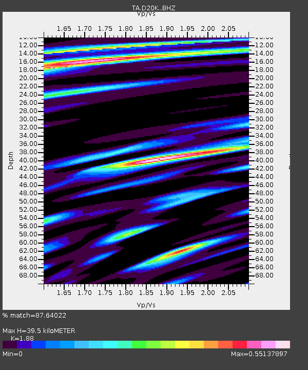
| Estimated Moho Depth: |
39.5 km |
| Estimated Crust Vp/Vs: |
1.88 |
| Assumed Crust Vp: |
6.221 km/s |
| Estimated Crust Vs: |
3.309 km/s |
| Estimated Crust Poisson's Ratio: |
0.30 |
|
| Radial Match: |
87.64022 % |
| Radial Bump: |
400 |
| Transverse Match: |
78.44597 % |
| Transverse Bump: |
400 |
| SOD ConfigId: |
13570011 |
| Insert Time: |
2019-04-30 05:12:48.202 +0000 |
| GWidth: |
2.5 |
| Max Bumps: |
400 |
| Tol: |
0.001 |
|

Signal To Noise
| Channel | StoN | STA | LTA |
| TA:D20K: :BHZ:20180505T06:30:00.524998Z | 9.142271 | 9.475974E-7 | 1.0365011E-7 |
| TA:D20K: :BHN:20180505T06:30:00.524998Z | 0.59928215 | 9.695966E-8 | 1.6179301E-7 |
| TA:D20K: :BHE:20180505T06:30:00.524998Z | 2.5624323 | 2.4905094E-7 | 9.719319E-8 |
| Arrivals |
| Ps | 5.8 SECOND |
| PpPs | 18 SECOND |
| PsPs/PpSs | 23 SECOND |


