You are here: Home > Network List > TA - USArray Transportable Network (new EarthScope stations) Stations List
> Station E22K Anaktuvuk Pass, AK, USA > Earthquake Result Viewer
E22K Anaktuvuk Pass, AK, USA - Earthquake Result Viewer
| Earthquake location: |
Luzon, Philippines |
| Earthquake latitude/longitude: |
14.5/123.9 |
| Earthquake time(UTC): |
2018/05/05 (125) 06:19:04 GMT |
| Earthquake Depth: |
18 km |
| Earthquake Magnitude: |
6.1 Mww |
| Earthquake Catalog/Contributor: |
NEIC PDE/us |
|
| Network: |
TA USArray Transportable Network (new EarthScope stations) |
| Station: |
E22K Anaktuvuk Pass, AK, USA |
| Lat/Lon: |
68.13 N/151.81 W |
| Elevation: |
772 m |
|
| Distance: |
74.5 deg |
| Az: |
22.752 deg |
| Baz: |
270.196 deg |
| Ray Param: |
0.052265428 |
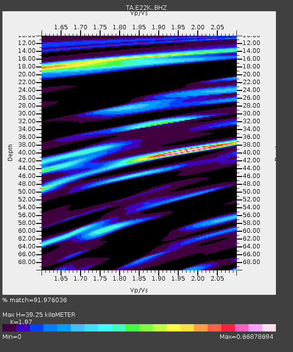
| Estimated Moho Depth: |
39.25 km |
| Estimated Crust Vp/Vs: |
1.97 |
| Assumed Crust Vp: |
6.221 km/s |
| Estimated Crust Vs: |
3.158 km/s |
| Estimated Crust Poisson's Ratio: |
0.33 |
|
| Radial Match: |
91.976036 % |
| Radial Bump: |
400 |
| Transverse Match: |
86.175705 % |
| Transverse Bump: |
400 |
| SOD ConfigId: |
13570011 |
| Insert Time: |
2019-04-30 05:12:57.450 +0000 |
| GWidth: |
2.5 |
| Max Bumps: |
400 |
| Tol: |
0.001 |
|

Signal To Noise
| Channel | StoN | STA | LTA |
| TA:E22K: :BHZ:20180505T06:30:10.800022Z | 5.9397683 | 7.7846533E-7 | 1.3105988E-7 |
| TA:E22K: :BHN:20180505T06:30:10.800022Z | 0.93683296 | 8.736035E-8 | 9.325072E-8 |
| TA:E22K: :BHE:20180505T06:30:10.800022Z | 3.0259078 | 2.0239399E-7 | 6.688703E-8 |
| Arrivals |
| Ps | 6.3 SECOND |
| PpPs | 18 SECOND |
| PsPs/PpSs | 25 SECOND |


