You are here: Home > Network List > TA - USArray Transportable Network (new EarthScope stations) Stations List
> Station F17K Baldwin Penninsula, AK, USA > Earthquake Result Viewer
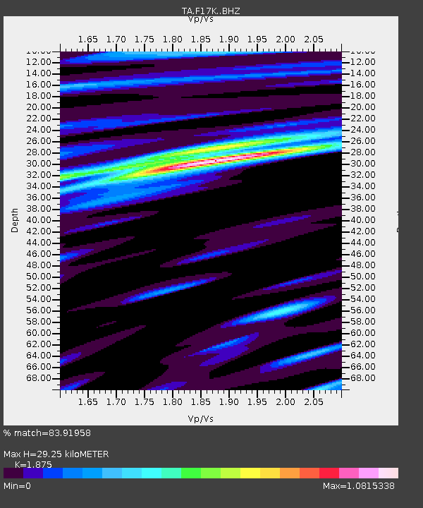
F17K Baldwin Penninsula, AK, USA - Earthquake Result Viewer
| Earthquake location: |
Luzon, Philippines |
| Earthquake latitude/longitude: |
14.5/123.9 |
| Earthquake time(UTC): |
2018/05/05 (125) 06:19:04 GMT |
| Earthquake Depth: |
18 km |
| Earthquake Magnitude: |
6.1 Mww |
| Earthquake Catalog/Contributor: |
NEIC PDE/us |
|
| Network: |
TA USArray Transportable Network (new EarthScope stations) |
| Station: |
F17K Baldwin Penninsula, AK, USA |
| Lat/Lon: |
66.44 N/161.25 W |
| Elevation: |
51 m |
|
| Distance: |
70.7 deg |
| Az: |
24.261 deg |
| Baz: |
261.946 deg |
| Ray Param: |
0.054761764 |
| Estimated Moho Depth: |
29.25 km |
| Estimated Crust Vp/Vs: |
1.88 |
| Assumed Crust Vp: |
6.276 km/s |
| Estimated Crust Vs: |
3.347 km/s |
| Estimated Crust Poisson's Ratio: |
0.30 |
|
| Radial Match: |
83.91958 % |
| Radial Bump: |
400 |
| Transverse Match: |
83.56032 % |
| Transverse Bump: |
400 |
| SOD ConfigId: |
13570011 |
| Insert Time: |
2019-04-30 05:13:03.576 +0000 |
| GWidth: |
2.5 |
| Max Bumps: |
400 |
| Tol: |
0.001 |
|

Signal To Noise
| Channel | StoN | STA | LTA |
| TA:F17K: :BHZ:20180505T06:29:48.449985Z | 6.608716 | 7.3360457E-7 | 1.1100561E-7 |
| TA:F17K: :BHN:20180505T06:29:48.449985Z | 1.11698 | 1.9177766E-7 | 1.7169302E-7 |
| TA:F17K: :BHE:20180505T06:29:48.449985Z | 2.969586 | 3.822673E-7 | 1.2872748E-7 |
| Arrivals |
| Ps | 4.2 SECOND |
| PpPs | 13 SECOND |
| PsPs/PpSs | 17 SECOND |


