You are here: Home > Network List > TA - USArray Transportable Network (new EarthScope stations) Stations List
> Station G15K Niukluk, AK, USA > Earthquake Result Viewer
G15K Niukluk, AK, USA - Earthquake Result Viewer
| Earthquake location: |
Luzon, Philippines |
| Earthquake latitude/longitude: |
14.5/123.9 |
| Earthquake time(UTC): |
2018/05/05 (125) 06:19:04 GMT |
| Earthquake Depth: |
18 km |
| Earthquake Magnitude: |
6.1 Mww |
| Earthquake Catalog/Contributor: |
NEIC PDE/us |
|
| Network: |
TA USArray Transportable Network (new EarthScope stations) |
| Station: |
G15K Niukluk, AK, USA |
| Lat/Lon: |
64.99 N/164.04 W |
| Elevation: |
249 m |
|
| Distance: |
69.4 deg |
| Az: |
25.594 deg |
| Baz: |
259.862 deg |
| Ray Param: |
0.055670284 |
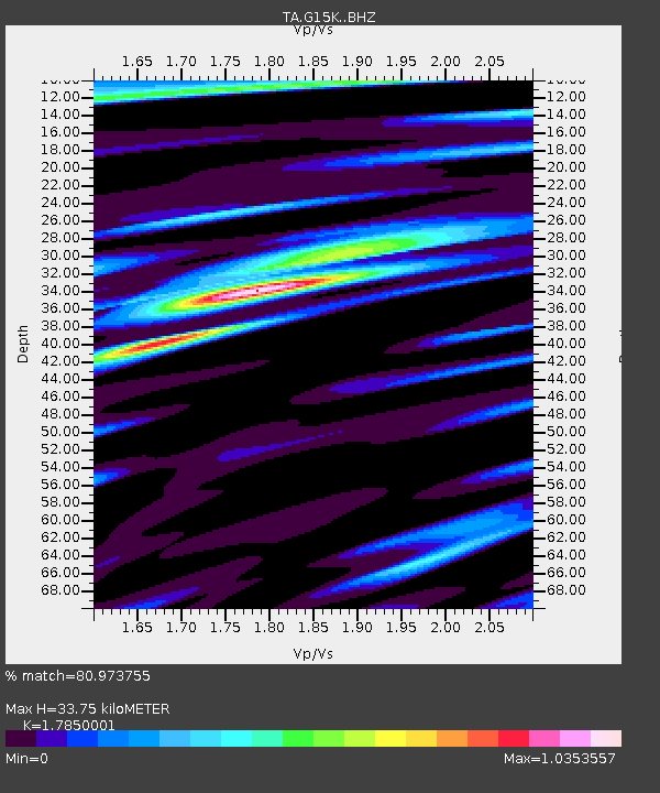
| Estimated Moho Depth: |
33.75 km |
| Estimated Crust Vp/Vs: |
1.79 |
| Assumed Crust Vp: |
6.276 km/s |
| Estimated Crust Vs: |
3.516 km/s |
| Estimated Crust Poisson's Ratio: |
0.27 |
|
| Radial Match: |
80.973755 % |
| Radial Bump: |
400 |
| Transverse Match: |
73.54606 % |
| Transverse Bump: |
400 |
| SOD ConfigId: |
13570011 |
| Insert Time: |
2019-04-30 05:13:13.045 +0000 |
| GWidth: |
2.5 |
| Max Bumps: |
400 |
| Tol: |
0.001 |
|

Signal To Noise
| Channel | StoN | STA | LTA |
| TA:G15K: :BHZ:20180505T06:29:40.074985Z | 3.0341334 | 4.917768E-7 | 1.6208146E-7 |
| TA:G15K: :BHN:20180505T06:29:40.074985Z | 1.3392174 | 2.2638419E-7 | 1.6904215E-7 |
| TA:G15K: :BHE:20180505T06:29:40.074985Z | 1.5664378 | 2.9649408E-7 | 1.8927919E-7 |
| Arrivals |
| Ps | 4.4 SECOND |
| PpPs | 14 SECOND |
| PsPs/PpSs | 19 SECOND |


