You are here: Home > Network List > TA - USArray Transportable Network (new EarthScope stations) Stations List
> Station G19K Purcell Mountains, AK, USA > Earthquake Result Viewer
G19K Purcell Mountains, AK, USA - Earthquake Result Viewer
| Earthquake location: |
Luzon, Philippines |
| Earthquake latitude/longitude: |
14.5/123.9 |
| Earthquake time(UTC): |
2018/05/05 (125) 06:19:04 GMT |
| Earthquake Depth: |
18 km |
| Earthquake Magnitude: |
6.1 Mww |
| Earthquake Catalog/Contributor: |
NEIC PDE/us |
|
| Network: |
TA USArray Transportable Network (new EarthScope stations) |
| Station: |
G19K Purcell Mountains, AK, USA |
| Lat/Lon: |
66.14 N/157.09 W |
| Elevation: |
391 m |
|
| Distance: |
72.4 deg |
| Az: |
24.762 deg |
| Baz: |
265.913 deg |
| Ray Param: |
0.053676575 |
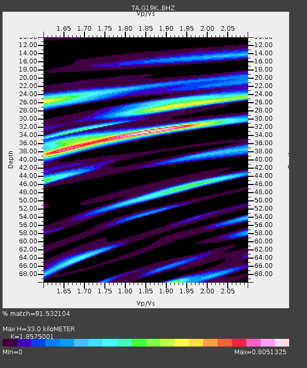
| Estimated Moho Depth: |
33.0 km |
| Estimated Crust Vp/Vs: |
1.86 |
| Assumed Crust Vp: |
6.577 km/s |
| Estimated Crust Vs: |
3.541 km/s |
| Estimated Crust Poisson's Ratio: |
0.30 |
|
| Radial Match: |
91.532104 % |
| Radial Bump: |
375 |
| Transverse Match: |
85.429436 % |
| Transverse Bump: |
400 |
| SOD ConfigId: |
13570011 |
| Insert Time: |
2019-04-30 05:13:16.020 +0000 |
| GWidth: |
2.5 |
| Max Bumps: |
400 |
| Tol: |
0.001 |
|

Signal To Noise
| Channel | StoN | STA | LTA |
| TA:G19K: :BHZ:20180505T06:29:58.324985Z | 5.706727 | 6.443018E-7 | 1.1290216E-7 |
| TA:G19K: :BHN:20180505T06:29:58.324985Z | 0.94467974 | 9.254667E-8 | 9.7966186E-8 |
| TA:G19K: :BHE:20180505T06:29:58.324985Z | 2.9634657 | 2.934501E-7 | 9.9022614E-8 |
| Arrivals |
| Ps | 4.5 SECOND |
| PpPs | 14 SECOND |
| PsPs/PpSs | 18 SECOND |


