You are here: Home > Network List > TA - USArray Transportable Network (new EarthScope stations) Stations List
> Station G29M Pine Creek, YT, CAN > Earthquake Result Viewer
G29M Pine Creek, YT, CAN - Earthquake Result Viewer
| Earthquake location: |
Luzon, Philippines |
| Earthquake latitude/longitude: |
14.5/123.9 |
| Earthquake time(UTC): |
2018/05/05 (125) 06:19:04 GMT |
| Earthquake Depth: |
18 km |
| Earthquake Magnitude: |
6.1 Mww |
| Earthquake Catalog/Contributor: |
NEIC PDE/us |
|
| Network: |
TA USArray Transportable Network (new EarthScope stations) |
| Station: |
G29M Pine Creek, YT, CAN |
| Lat/Lon: |
66.91 N/138.02 W |
| Elevation: |
572 m |
|
| Distance: |
79.9 deg |
| Az: |
23.368 deg |
| Baz: |
283.073 deg |
| Ray Param: |
0.048620347 |
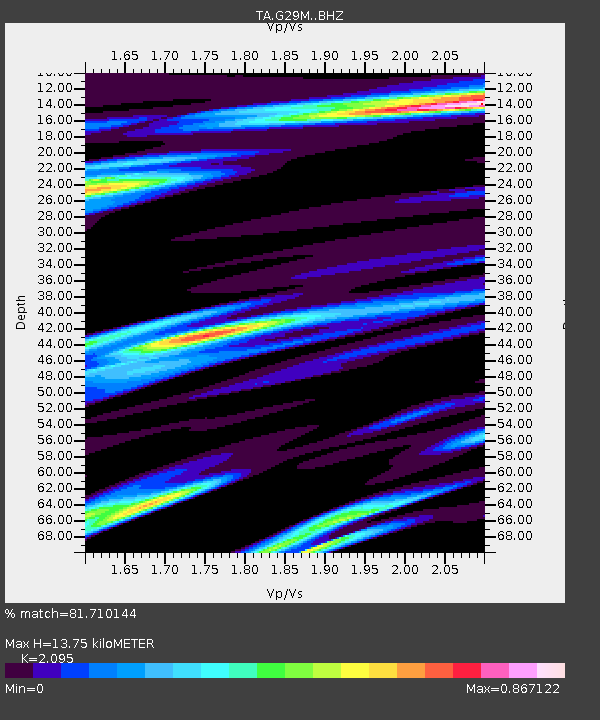
| Estimated Moho Depth: |
13.75 km |
| Estimated Crust Vp/Vs: |
2.10 |
| Assumed Crust Vp: |
6.577 km/s |
| Estimated Crust Vs: |
3.139 km/s |
| Estimated Crust Poisson's Ratio: |
0.35 |
|
| Radial Match: |
81.710144 % |
| Radial Bump: |
400 |
| Transverse Match: |
76.86042 % |
| Transverse Bump: |
400 |
| SOD ConfigId: |
13570011 |
| Insert Time: |
2019-04-30 05:13:23.042 +0000 |
| GWidth: |
2.5 |
| Max Bumps: |
400 |
| Tol: |
0.001 |
|

Signal To Noise
| Channel | StoN | STA | LTA |
| TA:G29M: :BHZ:20180505T06:30:41.024998Z | 5.331796 | 1.1532172E-6 | 2.1629059E-7 |
| TA:G29M: :BHN:20180505T06:30:41.024998Z | 1.1015644 | 2.5757558E-7 | 2.3382705E-7 |
| TA:G29M: :BHE:20180505T06:30:41.024998Z | 1.156143 | 2.764124E-7 | 2.390815E-7 |
| Arrivals |
| Ps | 2.3 SECOND |
| PpPs | 6.3 SECOND |
| PsPs/PpSs | 8.7 SECOND |


