You are here: Home > Network List > TA - USArray Transportable Network (new EarthScope stations) Stations List
> Station H23K Yukon River, AK, USA > Earthquake Result Viewer
H23K Yukon River, AK, USA - Earthquake Result Viewer
| Earthquake location: |
Luzon, Philippines |
| Earthquake latitude/longitude: |
14.5/123.9 |
| Earthquake time(UTC): |
2018/05/05 (125) 06:19:04 GMT |
| Earthquake Depth: |
18 km |
| Earthquake Magnitude: |
6.1 Mww |
| Earthquake Catalog/Contributor: |
NEIC PDE/us |
|
| Network: |
TA USArray Transportable Network (new EarthScope stations) |
| Station: |
H23K Yukon River, AK, USA |
| Lat/Lon: |
65.83 N/149.54 W |
| Elevation: |
617 m |
|
| Distance: |
75.5 deg |
| Az: |
25.128 deg |
| Baz: |
272.899 deg |
| Ray Param: |
0.051631194 |
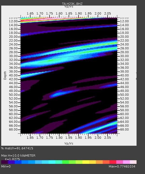
| Estimated Moho Depth: |
10.0 km |
| Estimated Crust Vp/Vs: |
1.83 |
| Assumed Crust Vp: |
6.566 km/s |
| Estimated Crust Vs: |
3.593 km/s |
| Estimated Crust Poisson's Ratio: |
0.29 |
|
| Radial Match: |
91.647415 % |
| Radial Bump: |
364 |
| Transverse Match: |
89.11191 % |
| Transverse Bump: |
400 |
| SOD ConfigId: |
13570011 |
| Insert Time: |
2019-04-30 05:13:28.880 +0000 |
| GWidth: |
2.5 |
| Max Bumps: |
400 |
| Tol: |
0.001 |
|

Signal To Noise
| Channel | StoN | STA | LTA |
| TA:H23K: :BHZ:20180505T06:30:16.324985Z | 4.6808467 | 7.425944E-7 | 1.5864532E-7 |
| TA:H23K: :BHN:20180505T06:30:16.324985Z | 0.45981076 | 7.730573E-8 | 1.681251E-7 |
| TA:H23K: :BHE:20180505T06:30:16.324985Z | 2.6063893 | 3.4367469E-7 | 1.3185854E-7 |
| Arrivals |
| Ps | 1.3 SECOND |
| PpPs | 4.2 SECOND |
| PsPs/PpSs | 5.5 SECOND |


