You are here: Home > Network List > TA - USArray Transportable Network (new EarthScope stations) Stations List
> Station J19K Poorman, AK, USA > Earthquake Result Viewer
J19K Poorman, AK, USA - Earthquake Result Viewer
| Earthquake location: |
Luzon, Philippines |
| Earthquake latitude/longitude: |
14.5/123.9 |
| Earthquake time(UTC): |
2018/05/05 (125) 06:19:04 GMT |
| Earthquake Depth: |
18 km |
| Earthquake Magnitude: |
6.1 Mww |
| Earthquake Catalog/Contributor: |
NEIC PDE/us |
|
| Network: |
TA USArray Transportable Network (new EarthScope stations) |
| Station: |
J19K Poorman, AK, USA |
| Lat/Lon: |
63.99 N/155.62 W |
| Elevation: |
389 m |
|
| Distance: |
72.9 deg |
| Az: |
27.056 deg |
| Baz: |
267.925 deg |
| Ray Param: |
0.05334596 |
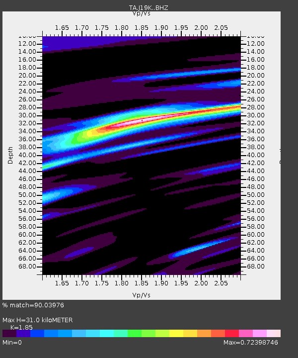
| Estimated Moho Depth: |
31.0 km |
| Estimated Crust Vp/Vs: |
1.85 |
| Assumed Crust Vp: |
6.438 km/s |
| Estimated Crust Vs: |
3.48 km/s |
| Estimated Crust Poisson's Ratio: |
0.29 |
|
| Radial Match: |
90.03976 % |
| Radial Bump: |
326 |
| Transverse Match: |
73.35067 % |
| Transverse Bump: |
400 |
| SOD ConfigId: |
13570011 |
| Insert Time: |
2019-04-30 05:13:43.453 +0000 |
| GWidth: |
2.5 |
| Max Bumps: |
400 |
| Tol: |
0.001 |
|

Signal To Noise
| Channel | StoN | STA | LTA |
| TA:J19K: :BHZ:20180505T06:30:01.324985Z | 2.5827236 | 4.1905912E-7 | 1.6225472E-7 |
| TA:J19K: :BHN:20180505T06:30:01.324985Z | 0.81089675 | 1.2911322E-7 | 1.5922276E-7 |
| TA:J19K: :BHE:20180505T06:30:01.324985Z | 1.5279694 | 2.8108934E-7 | 1.8396268E-7 |
| Arrivals |
| Ps | 4.2 SECOND |
| PpPs | 13 SECOND |
| PsPs/PpSs | 18 SECOND |


