You are here: Home > Network List > TA - USArray Transportable Network (new EarthScope stations) Stations List
> Station J29N Klondike Camp, Yukon, CA > Earthquake Result Viewer
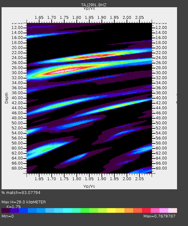
J29N Klondike Camp, Yukon, CA - Earthquake Result Viewer
| Earthquake location: |
Luzon, Philippines |
| Earthquake latitude/longitude: |
14.5/123.9 |
| Earthquake time(UTC): |
2018/05/05 (125) 06:19:04 GMT |
| Earthquake Depth: |
18 km |
| Earthquake Magnitude: |
6.1 Mww |
| Earthquake Catalog/Contributor: |
NEIC PDE/us |
|
| Network: |
TA USArray Transportable Network (new EarthScope stations) |
| Station: |
J29N Klondike Camp, Yukon, CA |
| Lat/Lon: |
64.45 N/138.22 W |
| Elevation: |
982 m |
|
| Distance: |
80.4 deg |
| Az: |
25.827 deg |
| Baz: |
283.317 deg |
| Ray Param: |
0.04828835 |
| Estimated Moho Depth: |
29.0 km |
| Estimated Crust Vp/Vs: |
1.75 |
| Assumed Crust Vp: |
6.566 km/s |
| Estimated Crust Vs: |
3.752 km/s |
| Estimated Crust Poisson's Ratio: |
0.26 |
|
| Radial Match: |
83.07794 % |
| Radial Bump: |
400 |
| Transverse Match: |
68.83377 % |
| Transverse Bump: |
400 |
| SOD ConfigId: |
13570011 |
| Insert Time: |
2019-04-30 05:13:47.558 +0000 |
| GWidth: |
2.5 |
| Max Bumps: |
400 |
| Tol: |
0.001 |
|

Signal To Noise
| Channel | StoN | STA | LTA |
| TA:J29N: :BHZ:20180505T06:30:43.649998Z | 2.2321296 | 6.177611E-7 | 2.767586E-7 |
| TA:J29N: :BHN:20180505T06:30:43.649998Z | 0.84610057 | 1.5364665E-7 | 1.8159385E-7 |
| TA:J29N: :BHE:20180505T06:30:43.649998Z | 1.6368072 | 2.624515E-7 | 1.6034356E-7 |
| Arrivals |
| Ps | 3.4 SECOND |
| PpPs | 12 SECOND |
| PsPs/PpSs | 15 SECOND |


