You are here: Home > Network List > TA - USArray Transportable Network (new EarthScope stations) Stations List
> Station K22A Casper, WY, USA > Earthquake Result Viewer
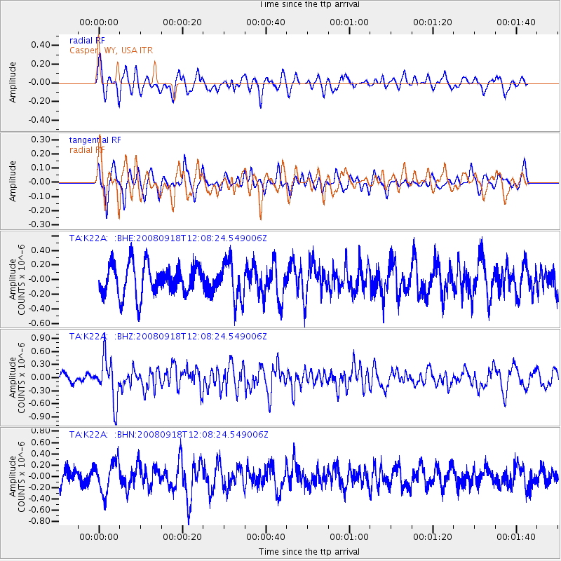
K22A Casper, WY, USA - Earthquake Result Viewer
*The percent match for this event was below the threshold and hence no stack was calculated.
| Earthquake location: |
Near East Coast Of Kamchatka |
| Earthquake latitude/longitude: |
51.9/158.4 |
| Earthquake time(UTC): |
2008/09/18 (262) 11:58:50 GMT |
| Earthquake Depth: |
67 km |
| Earthquake Magnitude: |
5.7 MB, 5.9 MW, 5.8 MW |
| Earthquake Catalog/Contributor: |
WHDF/NEIC |
|
| Network: |
TA USArray Transportable Network (new EarthScope stations) |
| Station: |
K22A Casper, WY, USA |
| Lat/Lon: |
42.65 N/106.52 W |
| Elevation: |
1686 m |
|
| Distance: |
60.7 deg |
| Az: |
57.427 deg |
| Baz: |
314.974 deg |
| Ray Param: |
$rayparam |
*The percent match for this event was below the threshold and hence was not used in the summary stack. |
|
| Radial Match: |
51.43076 % |
| Radial Bump: |
400 |
| Transverse Match: |
56.59606 % |
| Transverse Bump: |
396 |
| SOD ConfigId: |
2560 |
| Insert Time: |
2010-03-06 10:58:39.347 +0000 |
| GWidth: |
2.5 |
| Max Bumps: |
400 |
| Tol: |
0.001 |
|
Signal To Noise
| Channel | StoN | STA | LTA |
| TA:K22A: :BHZ:20080918T12:08:24.549006Z | 3.2692604 | 5.0687703E-7 | 1.5504334E-7 |
| TA:K22A: :BHN:20080918T12:08:24.549006Z | 1.677034 | 2.8254624E-7 | 1.6847973E-7 |
| TA:K22A: :BHE:20080918T12:08:24.549006Z | 1.31831 | 2.7882442E-7 | 2.115014E-7 |
| Arrivals |
| Ps | |
| PpPs | |
| PsPs/PpSs | |


