You are here: Home > Network List > G - GEOSCOPE Stations List
> Station CLF Chambon la Foret observatory, France > Earthquake Result Viewer
CLF Chambon la Foret observatory, France - Earthquake Result Viewer
| Earthquake location: |
Near Coast Of Ecuador |
| Earthquake latitude/longitude: |
0.4/-79.8 |
| Earthquake time(UTC): |
2016/05/18 (139) 07:57:05 GMT |
| Earthquake Depth: |
32 km |
| Earthquake Magnitude: |
6.7 MWP, 6.7 MWW, 6.7 MI |
| Earthquake Catalog/Contributor: |
NEIC PDE/NEIC COMCAT |
|
| Network: |
G GEOSCOPE |
| Station: |
CLF Chambon la Foret observatory, France |
| Lat/Lon: |
48.03 N/2.26 E |
| Elevation: |
145 m |
|
| Distance: |
84.3 deg |
| Az: |
41.916 deg |
| Baz: |
264.357 deg |
| Ray Param: |
0.045511153 |
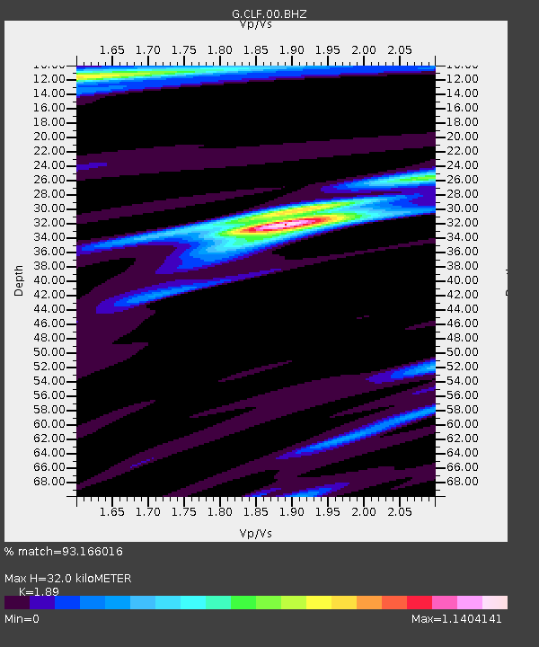
| Estimated Moho Depth: |
32.0 km |
| Estimated Crust Vp/Vs: |
1.89 |
| Assumed Crust Vp: |
6.12 km/s |
| Estimated Crust Vs: |
3.238 km/s |
| Estimated Crust Poisson's Ratio: |
0.31 |
|
| Radial Match: |
93.166016 % |
| Radial Bump: |
395 |
| Transverse Match: |
80.52432 % |
| Transverse Bump: |
348 |
| SOD ConfigId: |
1475611 |
| Insert Time: |
2016-06-01 07:59:57.892 +0000 |
| GWidth: |
2.5 |
| Max Bumps: |
400 |
| Tol: |
0.001 |
|
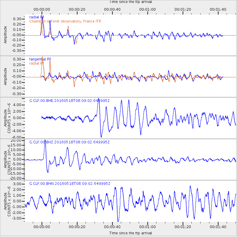
Signal To Noise
| Channel | StoN | STA | LTA |
| G:CLF:00:BHZ:20160518T08:09:02.649995Z | 34.275394 | 9.037826E-6 | 2.6368264E-7 |
| G:CLF:00:BHN:20160518T08:09:02.649995Z | 1.2911316 | 6.4885984E-7 | 5.025513E-7 |
| G:CLF:00:BHE:20160518T08:09:02.649995Z | 8.736203 | 3.4254397E-6 | 3.9209706E-7 |
| Arrivals |
| Ps | 4.8 SECOND |
| PpPs | 15 SECOND |
| PsPs/PpSs | 20 SECOND |


