You are here: Home > Network List > TA - USArray Transportable Network (new EarthScope stations) Stations List
> Station K22A Casper, WY, USA > Earthquake Result Viewer
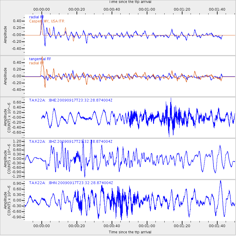
K22A Casper, WY, USA - Earthquake Result Viewer
*The percent match for this event was below the threshold and hence no stack was calculated.
| Earthquake location: |
Easter Island Region |
| Earthquake latitude/longitude: |
-29.1/-112.3 |
| Earthquake time(UTC): |
2009/09/17 (260) 23:21:38 GMT |
| Earthquake Depth: |
10 km |
| Earthquake Magnitude: |
5.7 MB, 6.0 MS, 6.2 MW, 6.2 MW |
| Earthquake Catalog/Contributor: |
WHDF/NEIC |
|
| Network: |
TA USArray Transportable Network (new EarthScope stations) |
| Station: |
K22A Casper, WY, USA |
| Lat/Lon: |
42.65 N/106.52 W |
| Elevation: |
1686 m |
|
| Distance: |
71.6 deg |
| Az: |
4.461 deg |
| Baz: |
185.292 deg |
| Ray Param: |
$rayparam |
*The percent match for this event was below the threshold and hence was not used in the summary stack. |
|
| Radial Match: |
77.11171 % |
| Radial Bump: |
400 |
| Transverse Match: |
48.217438 % |
| Transverse Bump: |
393 |
| SOD ConfigId: |
2622 |
| Insert Time: |
2010-03-06 10:59:01.140 +0000 |
| GWidth: |
2.5 |
| Max Bumps: |
400 |
| Tol: |
0.001 |
|
Signal To Noise
| Channel | StoN | STA | LTA |
| TA:K22A: :BHZ:20090917T23:32:28.874004Z | 3.093954 | 2.9827325E-7 | 9.6405195E-8 |
| TA:K22A: :BHN:20090917T23:32:28.874004Z | 1.0651808 | 1.8244381E-7 | 1.7127967E-7 |
| TA:K22A: :BHE:20090917T23:32:28.874004Z | 1.0704926 | 1.8024785E-7 | 1.6837842E-7 |
| Arrivals |
| Ps | |
| PpPs | |
| PsPs/PpSs | |


