You are here: Home > Network List > TA - USArray Transportable Network (new EarthScope stations) Stations List
> Station K22A Casper, WY, USA > Earthquake Result Viewer
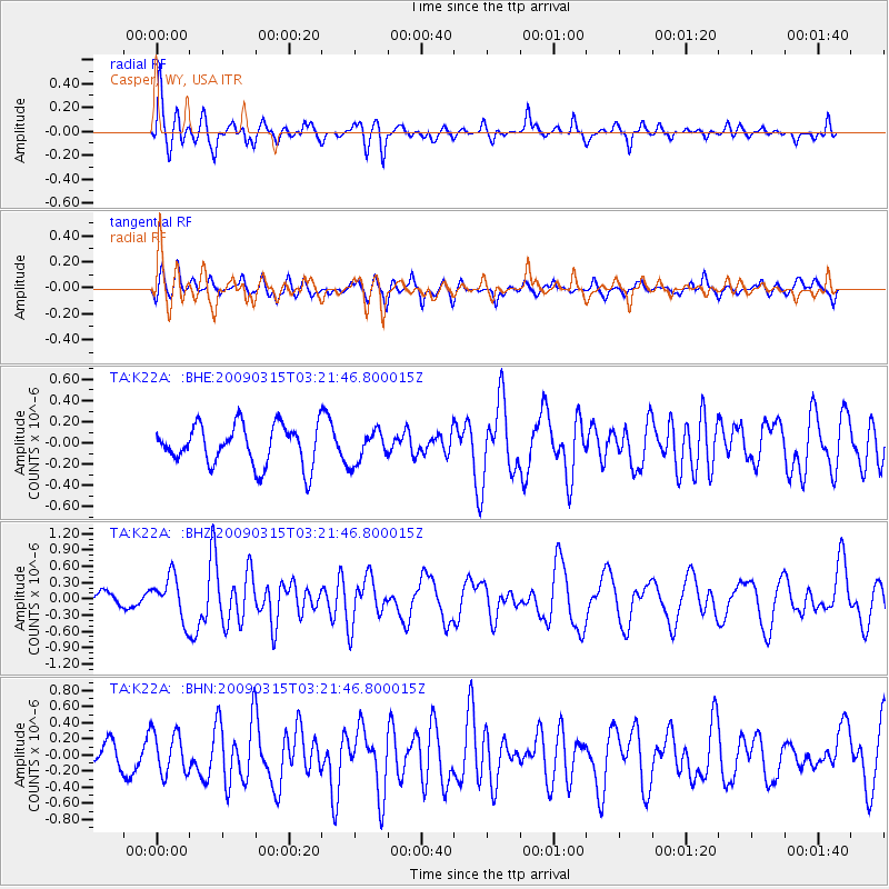
K22A Casper, WY, USA - Earthquake Result Viewer
*The percent match for this event was below the threshold and hence no stack was calculated.
| Earthquake location: |
Galapagos Islands Region |
| Earthquake latitude/longitude: |
2.4/-95.1 |
| Earthquake time(UTC): |
2009/03/15 (074) 03:14:31 GMT |
| Earthquake Depth: |
10 km |
| Earthquake Magnitude: |
5.5 MS, 5.4 MB, 5.8 MW, 5.8 MW |
| Earthquake Catalog/Contributor: |
WHDF/NEIC |
|
| Network: |
TA USArray Transportable Network (new EarthScope stations) |
| Station: |
K22A Casper, WY, USA |
| Lat/Lon: |
42.65 N/106.52 W |
| Elevation: |
1686 m |
|
| Distance: |
41.3 deg |
| Az: |
347.242 deg |
| Baz: |
162.598 deg |
| Ray Param: |
$rayparam |
*The percent match for this event was below the threshold and hence was not used in the summary stack. |
|
| Radial Match: |
69.28253 % |
| Radial Bump: |
391 |
| Transverse Match: |
57.69294 % |
| Transverse Bump: |
400 |
| SOD ConfigId: |
2658 |
| Insert Time: |
2010-03-06 10:59:36.043 +0000 |
| GWidth: |
2.5 |
| Max Bumps: |
400 |
| Tol: |
0.001 |
|
Signal To Noise
| Channel | StoN | STA | LTA |
| TA:K22A: :BHZ:20090315T03:21:46.800015Z | 2.4335563 | 3.9731347E-7 | 1.6326454E-7 |
| TA:K22A: :BHN:20090315T03:21:46.800015Z | 1.1210524 | 2.6020697E-7 | 2.3210956E-7 |
| TA:K22A: :BHE:20090315T03:21:46.800015Z | 0.7923619 | 1.4889108E-7 | 1.8790792E-7 |
| Arrivals |
| Ps | |
| PpPs | |
| PsPs/PpSs | |


