You are here: Home > Network List > GS - US Geological Survey Networks Stations List
> Station KAN12 Houston Home > Earthquake Result Viewer
KAN12 Houston Home - Earthquake Result Viewer
| Earthquake location: |
Near Coast Of Ecuador |
| Earthquake latitude/longitude: |
0.4/-79.8 |
| Earthquake time(UTC): |
2016/05/18 (139) 07:57:05 GMT |
| Earthquake Depth: |
32 km |
| Earthquake Magnitude: |
6.7 MWP, 6.7 MWW, 6.7 MI |
| Earthquake Catalog/Contributor: |
NEIC PDE/NEIC COMCAT |
|
| Network: |
GS US Geological Survey Networks |
| Station: |
KAN12 Houston Home |
| Lat/Lon: |
37.30 N/98.00 W |
| Elevation: |
426 m |
|
| Distance: |
40.4 deg |
| Az: |
337.343 deg |
| Baz: |
151.116 deg |
| Ray Param: |
0.07438044 |
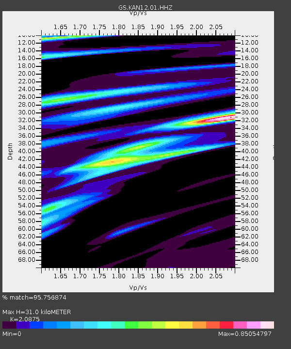
| Estimated Moho Depth: |
31.0 km |
| Estimated Crust Vp/Vs: |
2.09 |
| Assumed Crust Vp: |
6.483 km/s |
| Estimated Crust Vs: |
3.105 km/s |
| Estimated Crust Poisson's Ratio: |
0.35 |
|
| Radial Match: |
95.756874 % |
| Radial Bump: |
274 |
| Transverse Match: |
70.65041 % |
| Transverse Bump: |
400 |
| SOD ConfigId: |
1475611 |
| Insert Time: |
2016-06-01 08:02:48.573 +0000 |
| GWidth: |
2.5 |
| Max Bumps: |
400 |
| Tol: |
0.001 |
|

Signal To Noise
| Channel | StoN | STA | LTA |
| GS:KAN12:01:HHZ:20160518T08:04:09.295015Z | 23.303438 | 2.565256E-6 | 1.1008058E-7 |
| GS:KAN12:01:HHN:20160518T08:04:09.295015Z | 8.064461 | 1.4873162E-6 | 1.8442846E-7 |
| GS:KAN12:01:HHE:20160518T08:04:09.295015Z | 3.1499336 | 7.4487644E-7 | 2.364737E-7 |
| Arrivals |
| Ps | 5.5 SECOND |
| PpPs | 14 SECOND |
| PsPs/PpSs | 19 SECOND |


