You are here: Home > Network List > GS - US Geological Survey Networks Stations List
> Station KAN14 Livengood Farm - OK, Manchester, OK, USA > Earthquake Result Viewer
KAN14 Livengood Farm - OK, Manchester, OK, USA - Earthquake Result Viewer
| Earthquake location: |
Near Coast Of Ecuador |
| Earthquake latitude/longitude: |
0.4/-79.8 |
| Earthquake time(UTC): |
2016/05/18 (139) 07:57:05 GMT |
| Earthquake Depth: |
32 km |
| Earthquake Magnitude: |
6.7 MWP, 6.7 MWW, 6.7 MI |
| Earthquake Catalog/Contributor: |
NEIC PDE/NEIC COMCAT |
|
| Network: |
GS US Geological Survey Networks |
| Station: |
KAN14 Livengood Farm - OK, Manchester, OK, USA |
| Lat/Lon: |
36.96 N/97.96 W |
| Elevation: |
363 m |
|
| Distance: |
40.1 deg |
| Az: |
337.126 deg |
| Baz: |
150.971 deg |
| Ray Param: |
0.07454892 |
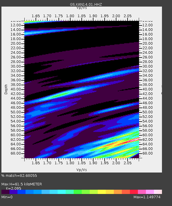
| Estimated Moho Depth: |
61.5 km |
| Estimated Crust Vp/Vs: |
2.10 |
| Assumed Crust Vp: |
6.483 km/s |
| Estimated Crust Vs: |
3.094 km/s |
| Estimated Crust Poisson's Ratio: |
0.35 |
|
| Radial Match: |
82.68055 % |
| Radial Bump: |
400 |
| Transverse Match: |
59.249187 % |
| Transverse Bump: |
400 |
| SOD ConfigId: |
1475611 |
| Insert Time: |
2016-06-01 08:03:01.669 +0000 |
| GWidth: |
2.5 |
| Max Bumps: |
400 |
| Tol: |
0.001 |
|

Signal To Noise
| Channel | StoN | STA | LTA |
| GS:KAN14:01:HHZ:20160518T08:04:06.725007Z | 17.373629 | 2.0767425E-6 | 1.1953419E-7 |
| GS:KAN14:01:HHN:20160518T08:04:06.725007Z | 7.9135914 | 1.3219204E-6 | 1.670443E-7 |
| GS:KAN14:01:HHE:20160518T08:04:06.725007Z | 2.4236698 | 3.107076E-6 | 1.2819717E-6 |
| Arrivals |
| Ps | 11 SECOND |
| PpPs | 28 SECOND |
| PsPs/PpSs | 39 SECOND |


