You are here: Home > Network List > TA - USArray Transportable Network (new EarthScope stations) Stations List
> Station K22A Casper, WY, USA > Earthquake Result Viewer
K22A Casper, WY, USA - Earthquake Result Viewer
*The percent match for this event was below the threshold and hence no stack was calculated.
| Earthquake location: |
Central Mid-Atlantic Ridge |
| Earthquake latitude/longitude: |
-0.3/-18.3 |
| Earthquake time(UTC): |
2008/07/27 (209) 21:15:41 GMT |
| Earthquake Depth: |
10 km |
| Earthquake Magnitude: |
5.8 MB, 5.3 MS, 5.9 MW, 5.8 MW |
| Earthquake Catalog/Contributor: |
WHDF/NEIC |
|
| Network: |
TA USArray Transportable Network (new EarthScope stations) |
| Station: |
K22A Casper, WY, USA |
| Lat/Lon: |
42.65 N/106.52 W |
| Elevation: |
1686 m |
|
| Distance: |
88.9 deg |
| Az: |
312.477 deg |
| Baz: |
91.387 deg |
| Ray Param: |
$rayparam |
*The percent match for this event was below the threshold and hence was not used in the summary stack. |
|
| Radial Match: |
61.47057 % |
| Radial Bump: |
400 |
| Transverse Match: |
53.168552 % |
| Transverse Bump: |
400 |
| SOD ConfigId: |
2504 |
| Insert Time: |
2010-03-06 10:59:47.910 +0000 |
| GWidth: |
2.5 |
| Max Bumps: |
400 |
| Tol: |
0.001 |
|
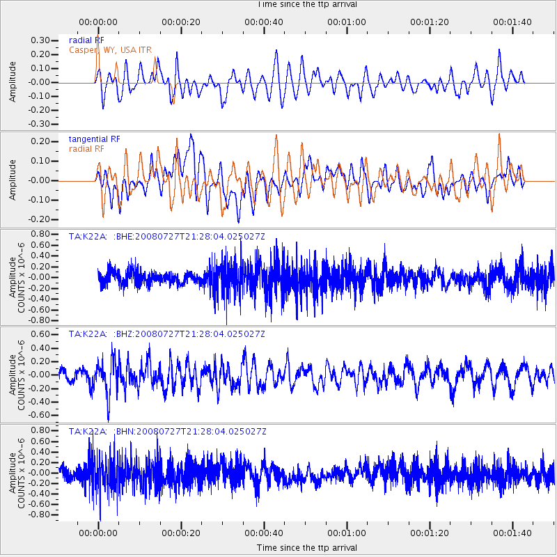
Signal To Noise
| Channel | StoN | STA | LTA |
| TA:K22A: :BHZ:20080727T21:28:04.025027Z | 3.162449 | 2.5043968E-7 | 7.919169E-8 |
| TA:K22A: :BHN:20080727T21:28:04.025027Z | 2.4136395 | 3.0459006E-7 | 1.2619535E-7 |
| TA:K22A: :BHE:20080727T21:28:04.025027Z | 2.6587048 | 2.9532137E-7 | 1.1107717E-7 |
| Arrivals |
| Ps | |
| PpPs | |
| PsPs/PpSs | |


