You are here: Home > Network List > GS - US Geological Survey Networks Stations List
> Station OK034 N. Norfolk Rd., Cushing, Oklahoma, USA > Earthquake Result Viewer
OK034 N. Norfolk Rd., Cushing, Oklahoma, USA - Earthquake Result Viewer
| Earthquake location: |
Near Coast Of Ecuador |
| Earthquake latitude/longitude: |
0.4/-79.8 |
| Earthquake time(UTC): |
2016/05/18 (139) 07:57:05 GMT |
| Earthquake Depth: |
32 km |
| Earthquake Magnitude: |
6.7 MWP, 6.7 MWW, 6.7 MI |
| Earthquake Catalog/Contributor: |
NEIC PDE/NEIC COMCAT |
|
| Network: |
GS US Geological Survey Networks |
| Station: |
OK034 N. Norfolk Rd., Cushing, Oklahoma, USA |
| Lat/Lon: |
36.01 N/96.71 W |
| Elevation: |
254 m |
|
| Distance: |
38.7 deg |
| Az: |
337.814 deg |
| Baz: |
152.243 deg |
| Ray Param: |
0.07532035 |
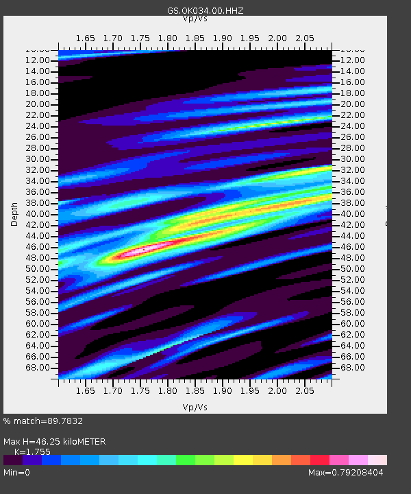
| Estimated Moho Depth: |
46.25 km |
| Estimated Crust Vp/Vs: |
1.75 |
| Assumed Crust Vp: |
6.483 km/s |
| Estimated Crust Vs: |
3.694 km/s |
| Estimated Crust Poisson's Ratio: |
0.26 |
|
| Radial Match: |
89.7832 % |
| Radial Bump: |
335 |
| Transverse Match: |
41.188774 % |
| Transverse Bump: |
400 |
| SOD ConfigId: |
1475611 |
| Insert Time: |
2016-06-01 08:03:45.056 +0000 |
| GWidth: |
2.5 |
| Max Bumps: |
400 |
| Tol: |
0.001 |
|

Signal To Noise
| Channel | StoN | STA | LTA |
| GS:OK034:00:HHZ:20160518T08:03:55.824006Z | 19.995342 | 2.094118E-6 | 1.0473028E-7 |
| GS:OK034:00:HH1:20160518T08:03:55.824006Z | 6.688512 | 1.1063802E-6 | 1.65415E-7 |
| GS:OK034:00:HH2:20160518T08:03:55.824006Z | 2.285051 | 5.8128995E-7 | 2.5438817E-7 |
| Arrivals |
| Ps | 5.8 SECOND |
| PpPs | 18 SECOND |
| PsPs/PpSs | 24 SECOND |


