You are here: Home > Network List > TA - USArray Transportable Network (new EarthScope stations) Stations List
> Station 833A Chaparral WMA, Artesia Wells, TX, USA > Earthquake Result Viewer
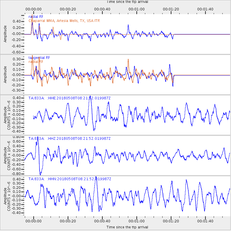
833A Chaparral WMA, Artesia Wells, TX, USA - Earthquake Result Viewer
*The percent match for this event was below the threshold and hence no stack was calculated.
| Earthquake location: |
Gulf Of Alaska |
| Earthquake latitude/longitude: |
56.4/-148.5 |
| Earthquake time(UTC): |
2018/05/08 (128) 08:14:12 GMT |
| Earthquake Depth: |
10 km |
| Earthquake Magnitude: |
5.5 Mww |
| Earthquake Catalog/Contributor: |
NEIC PDE/us |
|
| Network: |
TA USArray Transportable Network (new EarthScope stations) |
| Station: |
833A Chaparral WMA, Artesia Wells, TX, USA |
| Lat/Lon: |
28.32 N/99.39 W |
| Elevation: |
171 m |
|
| Distance: |
44.5 deg |
| Az: |
108.064 deg |
| Baz: |
323.117 deg |
| Ray Param: |
$rayparam |
*The percent match for this event was below the threshold and hence was not used in the summary stack. |
|
| Radial Match: |
62.86785 % |
| Radial Bump: |
400 |
| Transverse Match: |
50.88789 % |
| Transverse Bump: |
341 |
| SOD ConfigId: |
13570011 |
| Insert Time: |
2019-04-30 05:34:09.015 +0000 |
| GWidth: |
2.5 |
| Max Bumps: |
400 |
| Tol: |
0.001 |
|
Signal To Noise
| Channel | StoN | STA | LTA |
| TA:833A: :HHZ:20180508T08:21:52.019987Z | 4.30378 | 4.978099E-7 | 1.1566806E-7 |
| TA:833A: :HHN:20180508T08:21:52.019987Z | 1.503375 | 1.5515218E-7 | 1.0320258E-7 |
| TA:833A: :HHE:20180508T08:21:52.019987Z | 2.414229 | 2.7681853E-7 | 1.14661255E-7 |
| Arrivals |
| Ps | |
| PpPs | |
| PsPs/PpSs | |


