You are here: Home > Network List > TA - USArray Transportable Network (new EarthScope stations) Stations List
> Station 435B Jarrell, TX, USA > Earthquake Result Viewer
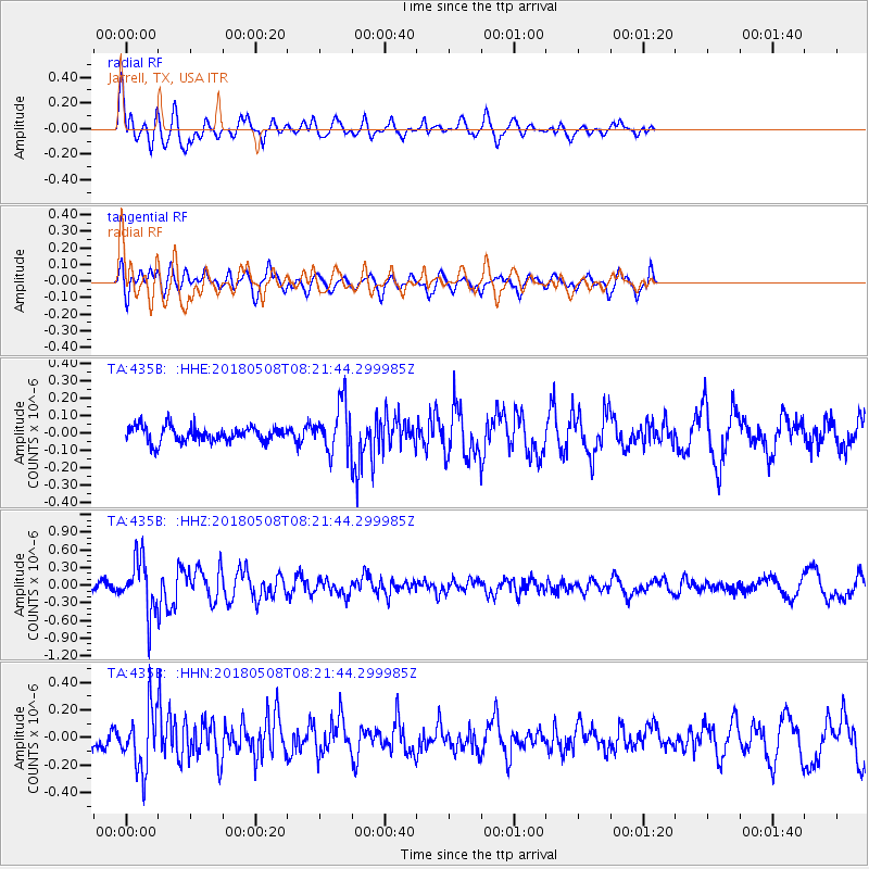
435B Jarrell, TX, USA - Earthquake Result Viewer
*The percent match for this event was below the threshold and hence no stack was calculated.
| Earthquake location: |
Gulf Of Alaska |
| Earthquake latitude/longitude: |
56.4/-148.5 |
| Earthquake time(UTC): |
2018/05/08 (128) 08:14:12 GMT |
| Earthquake Depth: |
10 km |
| Earthquake Magnitude: |
5.5 Mww |
| Earthquake Catalog/Contributor: |
NEIC PDE/us |
|
| Network: |
TA USArray Transportable Network (new EarthScope stations) |
| Station: |
435B Jarrell, TX, USA |
| Lat/Lon: |
30.78 N/97.58 W |
| Elevation: |
248 m |
|
| Distance: |
43.5 deg |
| Az: |
104.106 deg |
| Baz: |
321.156 deg |
| Ray Param: |
$rayparam |
*The percent match for this event was below the threshold and hence was not used in the summary stack. |
|
| Radial Match: |
53.446705 % |
| Radial Bump: |
400 |
| Transverse Match: |
70.809 % |
| Transverse Bump: |
400 |
| SOD ConfigId: |
13570011 |
| Insert Time: |
2019-04-30 05:34:09.643 +0000 |
| GWidth: |
2.5 |
| Max Bumps: |
400 |
| Tol: |
0.001 |
|
Signal To Noise
| Channel | StoN | STA | LTA |
| TA:435B: :HHZ:20180508T08:21:44.299985Z | 4.652203 | 4.479727E-7 | 9.629259E-8 |
| TA:435B: :HHN:20180508T08:21:44.299985Z | 2.610497 | 2.1700527E-7 | 8.312795E-8 |
| TA:435B: :HHE:20180508T08:21:44.299985Z | 3.6255472 | 1.609011E-7 | 4.437981E-8 |
| Arrivals |
| Ps | |
| PpPs | |
| PsPs/PpSs | |


