You are here: Home > Network List > IU - Global Seismograph Network (GSN - IRIS/USGS) Stations List
> Station RSSD Black Hills, South Dakota, USA > Earthquake Result Viewer
RSSD Black Hills, South Dakota, USA - Earthquake Result Viewer

| Earthquake location: |
Near Coast Of Ecuador |
| Earthquake latitude/longitude: |
0.4/-79.8 |
| Earthquake time(UTC): |
2016/05/18 (139) 07:57:05 GMT |
| Earthquake Depth: |
32 km |
| Earthquake Magnitude: |
6.7 MWP, 6.7 MWW, 6.7 MI |
| Earthquake Catalog/Contributor: |
NEIC PDE/NEIC COMCAT |
|
| Network: |
IU Global Seismograph Network (GSN - IRIS/USGS) |
| Station: |
RSSD Black Hills, South Dakota, USA |
| Lat/Lon: |
44.12 N/104.04 W |
| Elevation: |
2090 m |
|
| Distance: |
48.6 deg |
| Az: |
336.745 deg |
| Baz: |
146.756 deg |
| Ray Param: |
0.069208145 |
| Estimated Moho Depth: |
35.25 km |
| Estimated Crust Vp/Vs: |
2.05 |
| Assumed Crust Vp: |
6.242 km/s |
| Estimated Crust Vs: |
3.049 km/s |
| Estimated Crust Poisson's Ratio: |
0.34 |
|
| Radial Match: |
98.11426 % |
| Radial Bump: |
318 |
| Transverse Match: |
93.55585 % |
| Transverse Bump: |
400 |
| SOD ConfigId: |
1475611 |
| Insert Time: |
2016-06-01 08:06:12.997 +0000 |
| GWidth: |
2.5 |
| Max Bumps: |
400 |
| Tol: |
0.001 |
|
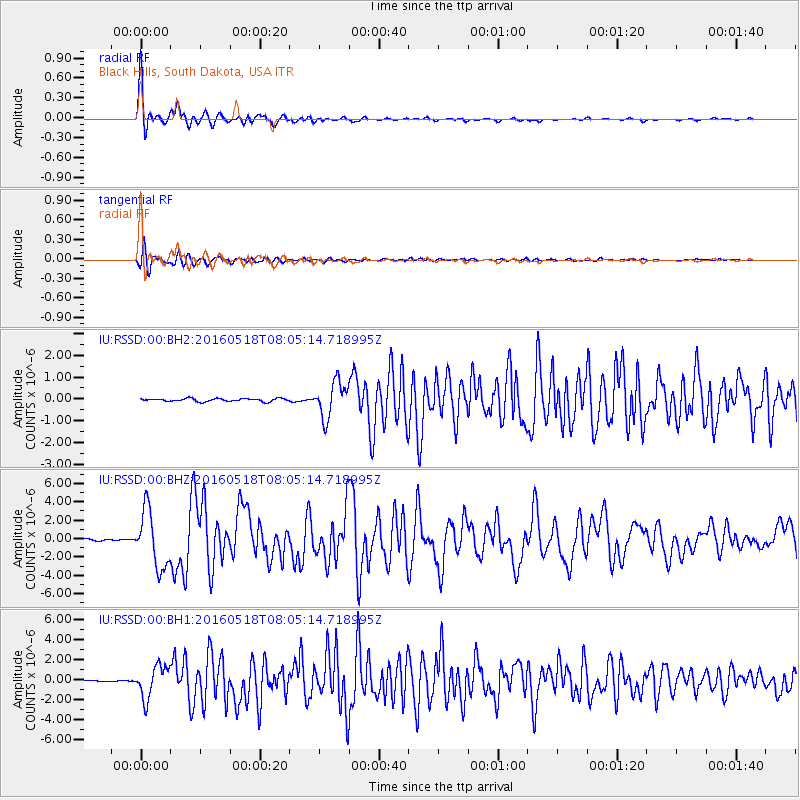
Signal To Noise
| Channel | StoN | STA | LTA |
| IU:RSSD:00:BHZ:20160518T08:05:14.718995Z | 28.036463 | 3.0951364E-6 | 1.10396826E-7 |
| IU:RSSD:00:BH1:20160518T08:05:14.718995Z | 21.023447 | 1.6086827E-6 | 7.65185E-8 |
| IU:RSSD:00:BH2:20160518T08:05:14.718995Z | 12.068653 | 8.0657577E-7 | 6.683229E-8 |
| Arrivals |
| Ps | 6.2 SECOND |
| PpPs | 16 SECOND |
| PsPs/PpSs | 23 SECOND |


