You are here: Home > Network List > CI - Caltech Regional Seismic Network Stations List
> Station TOV Thousand Oaks, California, USA > Earthquake Result Viewer
TOV Thousand Oaks, California, USA - Earthquake Result Viewer

| Earthquake location: |
Mariana Islands |
| Earthquake latitude/longitude: |
14.1/146.2 |
| Earthquake time(UTC): |
2002/08/14 (226) 13:57:52 GMT |
| Earthquake Depth: |
30 km |
| Earthquake Magnitude: |
6.1 MB, 6.4 MS, 6.5 MW, 6.4 MW |
| Earthquake Catalog/Contributor: |
WHDF/NEIC |
|
| Network: |
CI Caltech Regional Seismic Network |
| Station: |
TOV Thousand Oaks, California, USA |
| Lat/Lon: |
34.16 N/118.82 W |
| Elevation: |
50 m |
|
| Distance: |
86.2 deg |
| Az: |
55.884 deg |
| Baz: |
284.382 deg |
| Ray Param: |
0.04415013 |
| Estimated Moho Depth: |
60.25 km |
| Estimated Crust Vp/Vs: |
2.10 |
| Assumed Crust Vp: |
6.1 km/s |
| Estimated Crust Vs: |
2.908 km/s |
| Estimated Crust Poisson's Ratio: |
0.35 |
|
| Radial Match: |
87.989456 % |
| Radial Bump: |
400 |
| Transverse Match: |
86.6332 % |
| Transverse Bump: |
400 |
| SOD ConfigId: |
3770 |
| Insert Time: |
2010-02-26 01:57:03.667 +0000 |
| GWidth: |
2.5 |
| Max Bumps: |
400 |
| Tol: |
0.001 |
|
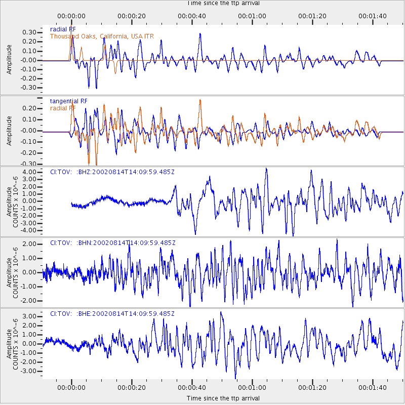
Signal To Noise
| Channel | StoN | STA | LTA |
| CI:TOV: :BHN:20020814T14:09:59.485Z | 0.9595466 | 2.7108248E-7 | 2.8251102E-7 |
| CI:TOV: :BHE:20020814T14:09:59.485Z | 0.72209024 | 3.4791748E-7 | 4.8181994E-7 |
| CI:TOV: :BHZ:20020814T14:09:59.485Z | 2.2720377 | 8.792988E-7 | 3.870089E-7 |
| Arrivals |
| Ps | 11 SECOND |
| PpPs | 30 SECOND |
| PsPs/PpSs | 41 SECOND |


