You are here: Home > Network List > TA - USArray Transportable Network (new EarthScope stations) Stations List
> Station E28M Babbage River, YT, CAN > Earthquake Result Viewer
E28M Babbage River, YT, CAN - Earthquake Result Viewer
| Earthquake location: |
New Britain Region, P.N.G. |
| Earthquake latitude/longitude: |
-5.9/151.8 |
| Earthquake time(UTC): |
2018/05/09 (129) 07:57:55 GMT |
| Earthquake Depth: |
10 km |
| Earthquake Magnitude: |
6.0 Mww |
| Earthquake Catalog/Contributor: |
NEIC PDE/us |
|
| Network: |
TA USArray Transportable Network (new EarthScope stations) |
| Station: |
E28M Babbage River, YT, CAN |
| Lat/Lon: |
68.60 N/139.53 W |
| Elevation: |
474 m |
|
| Distance: |
87.8 deg |
| Az: |
20.001 deg |
| Baz: |
248.019 deg |
| Ray Param: |
0.04304116 |
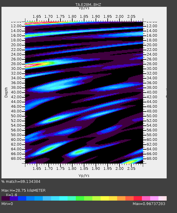
| Estimated Moho Depth: |
28.75 km |
| Estimated Crust Vp/Vs: |
1.60 |
| Assumed Crust Vp: |
6.316 km/s |
| Estimated Crust Vs: |
3.948 km/s |
| Estimated Crust Poisson's Ratio: |
0.18 |
|
| Radial Match: |
89.134384 % |
| Radial Bump: |
400 |
| Transverse Match: |
88.77419 % |
| Transverse Bump: |
400 |
| SOD ConfigId: |
13570011 |
| Insert Time: |
2019-04-30 05:40:53.414 +0000 |
| GWidth: |
2.5 |
| Max Bumps: |
400 |
| Tol: |
0.001 |
|

Signal To Noise
| Channel | StoN | STA | LTA |
| TA:E28M: :BHZ:20180509T08:10:13.075012Z | 4.7894692 | 4.1291338E-7 | 8.6212765E-8 |
| TA:E28M: :BHN:20180509T08:10:13.075012Z | 1.6338185 | 8.838175E-8 | 5.409521E-8 |
| TA:E28M: :BHE:20180509T08:10:13.075012Z | 2.246187 | 1.5242527E-7 | 6.785957E-8 |
| Arrivals |
| Ps | 2.8 SECOND |
| PpPs | 12 SECOND |
| PsPs/PpSs | 14 SECOND |


