You are here: Home > Network List > TA - USArray Transportable Network (new EarthScope stations) Stations List
> Station F22K John River, AK, USA > Earthquake Result Viewer
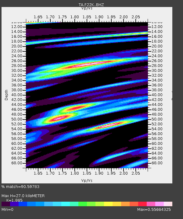
F22K John River, AK, USA - Earthquake Result Viewer
| Earthquake location: |
New Britain Region, P.N.G. |
| Earthquake latitude/longitude: |
-5.9/151.8 |
| Earthquake time(UTC): |
2018/05/09 (129) 07:57:55 GMT |
| Earthquake Depth: |
10 km |
| Earthquake Magnitude: |
6.0 Mww |
| Earthquake Catalog/Contributor: |
NEIC PDE/us |
|
| Network: |
TA USArray Transportable Network (new EarthScope stations) |
| Station: |
F22K John River, AK, USA |
| Lat/Lon: |
67.51 N/152.18 W |
| Elevation: |
546 m |
|
| Distance: |
83.1 deg |
| Az: |
18.747 deg |
| Baz: |
236.195 deg |
| Ray Param: |
0.046412874 |
| Estimated Moho Depth: |
27.0 km |
| Estimated Crust Vp/Vs: |
1.87 |
| Assumed Crust Vp: |
6.455 km/s |
| Estimated Crust Vs: |
3.461 km/s |
| Estimated Crust Poisson's Ratio: |
0.30 |
|
| Radial Match: |
90.59783 % |
| Radial Bump: |
380 |
| Transverse Match: |
71.1861 % |
| Transverse Bump: |
400 |
| SOD ConfigId: |
13570011 |
| Insert Time: |
2019-04-30 05:41:01.211 +0000 |
| GWidth: |
2.5 |
| Max Bumps: |
400 |
| Tol: |
0.001 |
|

Signal To Noise
| Channel | StoN | STA | LTA |
| TA:F22K: :BHZ:20180509T08:09:49.700012Z | 4.2877536 | 3.7871325E-7 | 8.8324406E-8 |
| TA:F22K: :BHN:20180509T08:09:49.700012Z | 1.8776771 | 2.2324933E-7 | 1.18896544E-7 |
| TA:F22K: :BHE:20180509T08:09:49.700012Z | 2.0288363 | 1.08361355E-7 | 5.34106E-8 |
| Arrivals |
| Ps | 3.7 SECOND |
| PpPs | 12 SECOND |
| PsPs/PpSs | 15 SECOND |


