You are here: Home > Network List > TA - USArray Transportable Network (new EarthScope stations) Stations List
> Station F24K Squaw Lake, AK, USA > Earthquake Result Viewer
F24K Squaw Lake, AK, USA - Earthquake Result Viewer
| Earthquake location: |
New Britain Region, P.N.G. |
| Earthquake latitude/longitude: |
-5.9/151.8 |
| Earthquake time(UTC): |
2018/05/09 (129) 07:57:55 GMT |
| Earthquake Depth: |
10 km |
| Earthquake Magnitude: |
6.0 Mww |
| Earthquake Catalog/Contributor: |
NEIC PDE/us |
|
| Network: |
TA USArray Transportable Network (new EarthScope stations) |
| Station: |
F24K Squaw Lake, AK, USA |
| Lat/Lon: |
67.52 N/147.89 W |
| Elevation: |
736 m |
|
| Distance: |
84.5 deg |
| Az: |
19.612 deg |
| Baz: |
240.25 deg |
| Ray Param: |
0.04541719 |
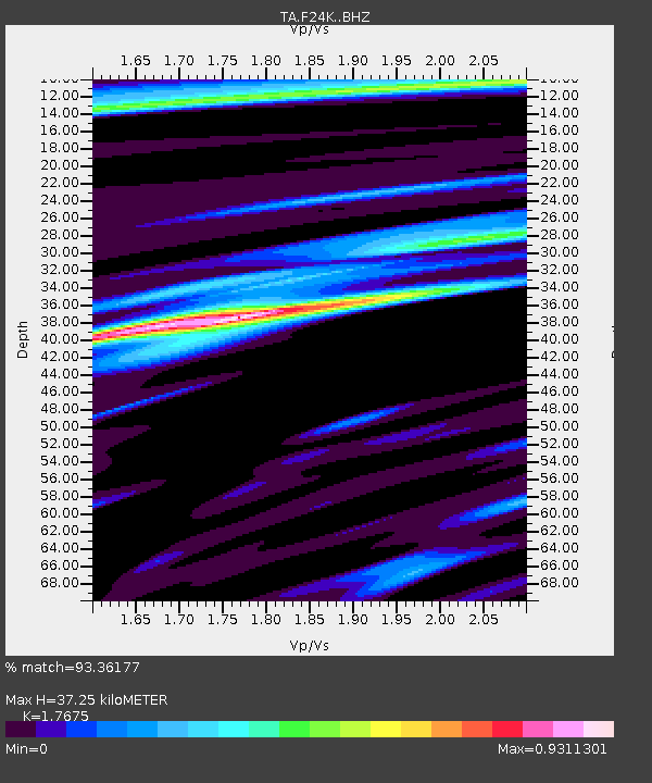
| Estimated Moho Depth: |
37.25 km |
| Estimated Crust Vp/Vs: |
1.77 |
| Assumed Crust Vp: |
6.522 km/s |
| Estimated Crust Vs: |
3.69 km/s |
| Estimated Crust Poisson's Ratio: |
0.26 |
|
| Radial Match: |
93.36177 % |
| Radial Bump: |
400 |
| Transverse Match: |
80.99552 % |
| Transverse Bump: |
400 |
| SOD ConfigId: |
13570011 |
| Insert Time: |
2019-04-30 05:41:02.097 +0000 |
| GWidth: |
2.5 |
| Max Bumps: |
400 |
| Tol: |
0.001 |
|
Signal To Noise
| Channel | StoN | STA | LTA |
| TA:F24K: :BHZ:20180509T08:09:56.900024Z | 5.143226 | 4.7157656E-7 | 9.168887E-8 |
| TA:F24K: :BHN:20180509T08:09:56.900024Z | 3.291844 | 1.9373836E-7 | 5.8854056E-8 |
| TA:F24K: :BHE:20180509T08:09:56.900024Z | 2.0899236 | 1.8121612E-7 | 8.670944E-8 |
| Arrivals |
| Ps | 4.5 SECOND |
| PpPs | 15 SECOND |
| PsPs/PpSs | 20 SECOND |


