You are here: Home > Network List > IW - Intermountain West Stations List
> Station MOOW Moose Ponds, Wyoming, USA > Earthquake Result Viewer
MOOW Moose Ponds, Wyoming, USA - Earthquake Result Viewer
| Earthquake location: |
Near Coast Of Ecuador |
| Earthquake latitude/longitude: |
0.4/-79.8 |
| Earthquake time(UTC): |
2016/05/18 (139) 07:57:05 GMT |
| Earthquake Depth: |
32 km |
| Earthquake Magnitude: |
6.7 MWP, 6.7 MWW, 6.7 MI |
| Earthquake Catalog/Contributor: |
NEIC PDE/NEIC COMCAT |
|
| Network: |
IW Intermountain West |
| Station: |
MOOW Moose Ponds, Wyoming, USA |
| Lat/Lon: |
43.75 N/110.74 W |
| Elevation: |
2128 m |
|
| Distance: |
51.2 deg |
| Az: |
331.409 deg |
| Baz: |
138.675 deg |
| Ray Param: |
0.06749621 |
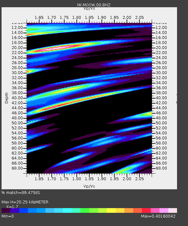
| Estimated Moho Depth: |
20.25 km |
| Estimated Crust Vp/Vs: |
1.70 |
| Assumed Crust Vp: |
6.207 km/s |
| Estimated Crust Vs: |
3.651 km/s |
| Estimated Crust Poisson's Ratio: |
0.24 |
|
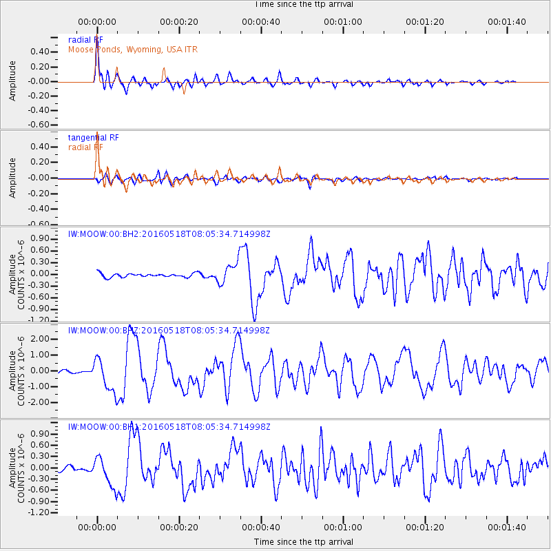
| Radial Match: |
89.47581 % |
| Radial Bump: |
400 |
| Transverse Match: |
71.57638 % |
| Transverse Bump: |
400 |
| SOD ConfigId: |
1475611 |
| Insert Time: |
2016-06-01 08:07:21.059 +0000 |
| GWidth: |
2.5 |
| Max Bumps: |
400 |
| Tol: |
0.001 |
|
Signal To Noise
| Channel | StoN | STA | LTA |
| IW:MOOW:00:BHZ:20160518T08:05:34.714998Z | 11.26004 | 1.0765788E-6 | 9.561056E-8 |
| IW:MOOW:00:BH1:20160518T08:05:34.714998Z | 6.931806 | 4.009457E-7 | 5.784145E-8 |
| IW:MOOW:00:BH2:20160518T08:05:34.714998Z | 5.95967 | 2.8669547E-7 | 4.8105925E-8 |
| Arrivals |
| Ps | 2.4 SECOND |
| PpPs | 8.3 SECOND |
| PsPs/PpSs | 11 SECOND |


