You are here: Home > Network List > AK - Alaska Regional Network Stations List
> Station COLD Coldfoot Broadband > Earthquake Result Viewer
COLD Coldfoot Broadband - Earthquake Result Viewer
| Earthquake location: |
Afghanistan-Tajikistan Bord Reg. |
| Earthquake latitude/longitude: |
37.0/71.4 |
| Earthquake time(UTC): |
2018/05/09 (129) 10:41:45 GMT |
| Earthquake Depth: |
112 km |
| Earthquake Magnitude: |
6.2 Mww |
| Earthquake Catalog/Contributor: |
NEIC PDE/us |
|
| Network: |
AK Alaska Regional Network |
| Station: |
COLD Coldfoot Broadband |
| Lat/Lon: |
67.23 N/150.20 W |
| Elevation: |
377 m |
|
| Distance: |
71.4 deg |
| Az: |
15.814 deg |
| Baz: |
325.91 deg |
| Ray Param: |
0.054057773 |
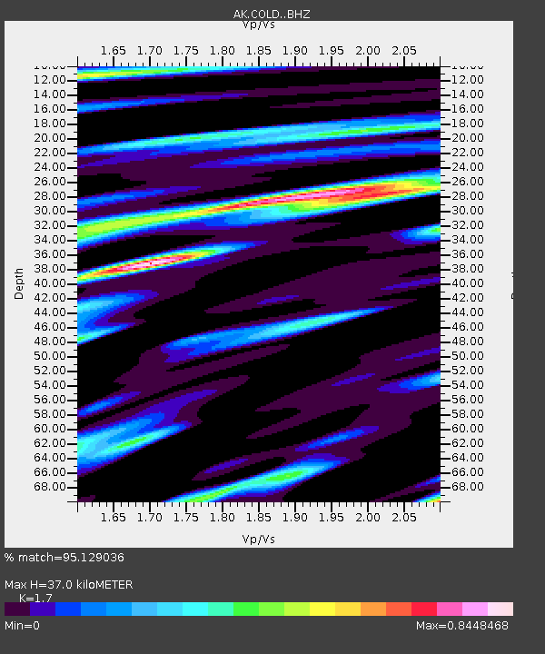
| Estimated Moho Depth: |
37.0 km |
| Estimated Crust Vp/Vs: |
1.70 |
| Assumed Crust Vp: |
6.577 km/s |
| Estimated Crust Vs: |
3.869 km/s |
| Estimated Crust Poisson's Ratio: |
0.24 |
|
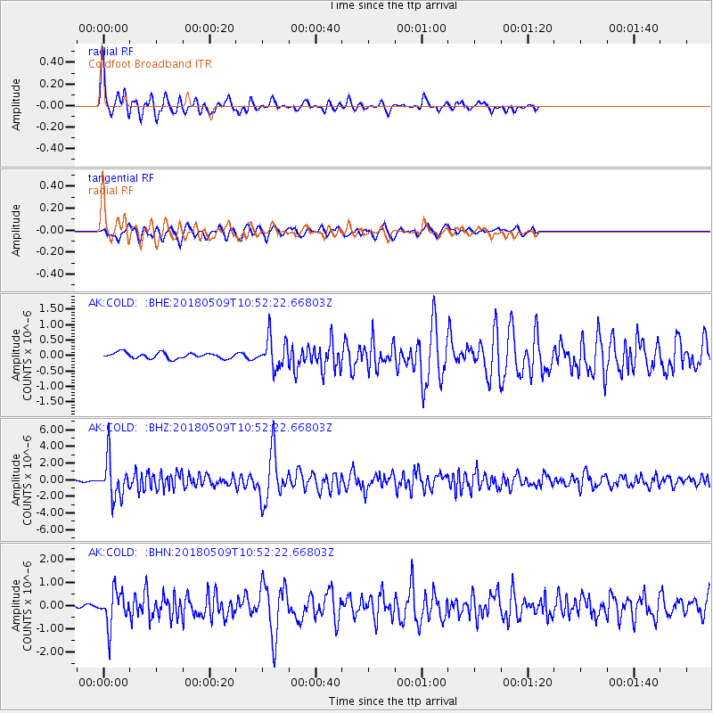
| Radial Match: |
95.129036 % |
| Radial Bump: |
400 |
| Transverse Match: |
85.85326 % |
| Transverse Bump: |
400 |
| SOD ConfigId: |
13570011 |
| Insert Time: |
2019-04-30 05:44:21.223 +0000 |
| GWidth: |
2.5 |
| Max Bumps: |
400 |
| Tol: |
0.001 |
|
Signal To Noise
| Channel | StoN | STA | LTA |
| AK:COLD: :BHZ:20180509T10:52:22.66803Z | 31.427647 | 2.2860104E-6 | 7.2738835E-8 |
| AK:COLD: :BHN:20180509T10:52:22.66803Z | 11.658676 | 7.6468194E-7 | 6.5589084E-8 |
| AK:COLD: :BHE:20180509T10:52:22.66803Z | 5.266284 | 4.967359E-7 | 9.4323795E-8 |
| Arrivals |
| Ps | 4.1 SECOND |
| PpPs | 15 SECOND |
| PsPs/PpSs | 19 SECOND |


