You are here: Home > Network List > AK - Alaska Regional Network Stations List
> Station PPD Porcupine Dome, AK, USA > Earthquake Result Viewer
PPD Porcupine Dome, AK, USA - Earthquake Result Viewer
| Earthquake location: |
Afghanistan-Tajikistan Bord Reg. |
| Earthquake latitude/longitude: |
37.0/71.4 |
| Earthquake time(UTC): |
2018/05/09 (129) 10:41:45 GMT |
| Earthquake Depth: |
112 km |
| Earthquake Magnitude: |
6.2 Mww |
| Earthquake Catalog/Contributor: |
NEIC PDE/us |
|
| Network: |
AK Alaska Regional Network |
| Station: |
PPD Porcupine Dome, AK, USA |
| Lat/Lon: |
65.52 N/145.52 W |
| Elevation: |
1498 m |
|
| Distance: |
73.9 deg |
| Az: |
15.093 deg |
| Baz: |
329.981 deg |
| Ray Param: |
0.052436702 |
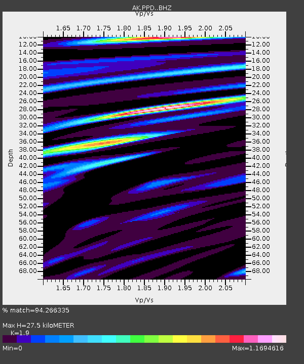
| Estimated Moho Depth: |
27.5 km |
| Estimated Crust Vp/Vs: |
1.90 |
| Assumed Crust Vp: |
6.566 km/s |
| Estimated Crust Vs: |
3.456 km/s |
| Estimated Crust Poisson's Ratio: |
0.31 |
|
| Radial Match: |
94.266335 % |
| Radial Bump: |
363 |
| Transverse Match: |
86.22171 % |
| Transverse Bump: |
400 |
| SOD ConfigId: |
13570011 |
| Insert Time: |
2019-04-30 05:44:52.113 +0000 |
| GWidth: |
2.5 |
| Max Bumps: |
400 |
| Tol: |
0.001 |
|

Signal To Noise
| Channel | StoN | STA | LTA |
| AK:PPD: :BHZ:20180509T10:52:37.16803Z | 26.8108 | 2.0728803E-6 | 7.731512E-8 |
| AK:PPD: :BHN:20180509T10:52:37.16803Z | 10.459438 | 6.9642414E-7 | 6.658332E-8 |
| AK:PPD: :BHE:20180509T10:52:37.16803Z | 5.067947 | 3.9570395E-7 | 7.807973E-8 |
| Arrivals |
| Ps | 3.9 SECOND |
| PpPs | 12 SECOND |
| PsPs/PpSs | 16 SECOND |


