You are here: Home > Network List > CN - Canadian National Seismograph Network Stations List
> Station FRB IQALUIT, N.W.T. > Earthquake Result Viewer
FRB IQALUIT, N.W.T. - Earthquake Result Viewer
| Earthquake location: |
Afghanistan-Tajikistan Bord Reg. |
| Earthquake latitude/longitude: |
37.0/71.4 |
| Earthquake time(UTC): |
2018/05/09 (129) 10:41:45 GMT |
| Earthquake Depth: |
112 km |
| Earthquake Magnitude: |
6.2 Mww |
| Earthquake Catalog/Contributor: |
NEIC PDE/us |
|
| Network: |
CN Canadian National Seismograph Network |
| Station: |
FRB IQALUIT, N.W.T. |
| Lat/Lon: |
63.75 N/68.55 W |
| Elevation: |
18 m |
|
| Distance: |
74.7 deg |
| Az: |
342.727 deg |
| Baz: |
32.314 deg |
| Ray Param: |
0.05190067 |
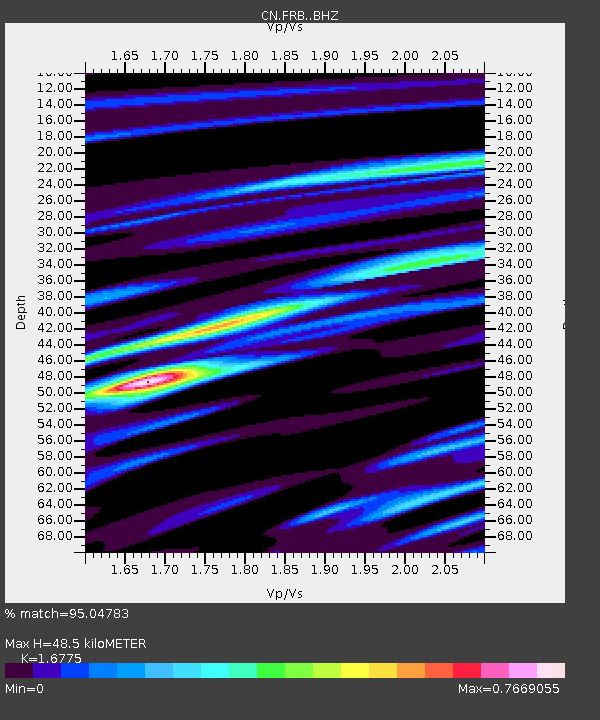
| Estimated Moho Depth: |
48.5 km |
| Estimated Crust Vp/Vs: |
1.68 |
| Assumed Crust Vp: |
6.419 km/s |
| Estimated Crust Vs: |
3.827 km/s |
| Estimated Crust Poisson's Ratio: |
0.22 |
|
| Radial Match: |
95.04783 % |
| Radial Bump: |
400 |
| Transverse Match: |
81.36124 % |
| Transverse Bump: |
400 |
| SOD ConfigId: |
13570011 |
| Insert Time: |
2019-04-30 05:46:33.782 +0000 |
| GWidth: |
2.5 |
| Max Bumps: |
400 |
| Tol: |
0.001 |
|

Signal To Noise
| Channel | StoN | STA | LTA |
| CN:FRB: :BHZ:20180509T10:52:41.875Z | 18.13176 | 1.4948505E-6 | 8.2443755E-8 |
| CN:FRB: :BHN:20180509T10:52:41.875Z | 6.4122443 | 5.044811E-7 | 7.8674645E-8 |
| CN:FRB: :BHE:20180509T10:52:41.875Z | 2.9900146 | 3.353588E-7 | 1.1215958E-7 |
| Arrivals |
| Ps | 5.3 SECOND |
| PpPs | 20 SECOND |
| PsPs/PpSs | 25 SECOND |


