You are here: Home > Network List > TA - USArray Transportable Network (new EarthScope stations) Stations List
> Station H20A Greybull, WY, USA > Earthquake Result Viewer
H20A Greybull, WY, USA - Earthquake Result Viewer
| Earthquake location: |
North Of Severnaya Zemlya |
| Earthquake latitude/longitude: |
83.6/115.2 |
| Earthquake time(UTC): |
2008/08/13 (226) 08:35:02 GMT |
| Earthquake Depth: |
10 km |
| Earthquake Magnitude: |
5.5 MB, 4.7 MS, 5.4 MW, 5.4 MW |
| Earthquake Catalog/Contributor: |
WHDF/NEIC |
|
| Network: |
TA USArray Transportable Network (new EarthScope stations) |
| Station: |
H20A Greybull, WY, USA |
| Lat/Lon: |
44.49 N/108.00 W |
| Elevation: |
1236 m |
|
| Distance: |
50.5 deg |
| Az: |
39.447 deg |
| Baz: |
354.32 deg |
| Ray Param: |
0.068004794 |
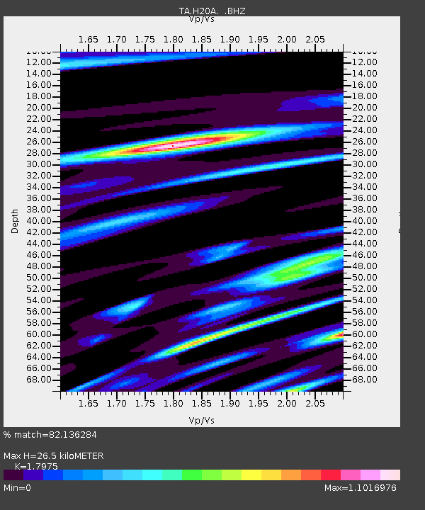
| Estimated Moho Depth: |
26.5 km |
| Estimated Crust Vp/Vs: |
1.80 |
| Assumed Crust Vp: |
6.178 km/s |
| Estimated Crust Vs: |
3.437 km/s |
| Estimated Crust Poisson's Ratio: |
0.28 |
|
| Radial Match: |
82.136284 % |
| Radial Bump: |
400 |
| Transverse Match: |
71.131134 % |
| Transverse Bump: |
400 |
| SOD ConfigId: |
2504 |
| Insert Time: |
2010-03-06 11:03:50.838 +0000 |
| GWidth: |
2.5 |
| Max Bumps: |
400 |
| Tol: |
0.001 |
|
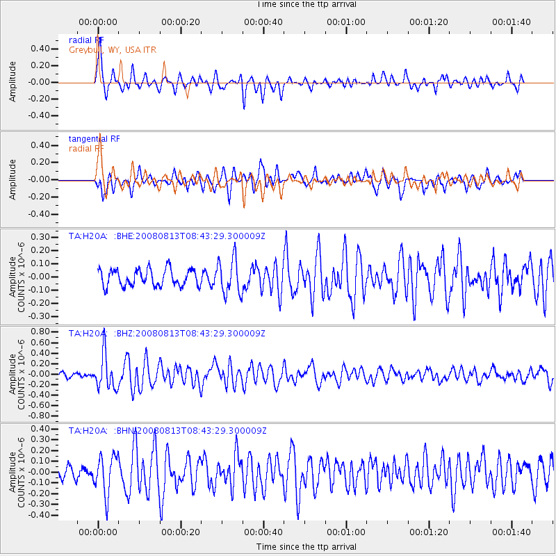
Signal To Noise
| Channel | StoN | STA | LTA |
| TA:H20A: :BHZ:20080813T08:43:29.300009Z | 4.414596 | 3.36408E-7 | 7.620357E-8 |
| TA:H20A: :BHN:20080813T08:43:29.300009Z | 2.736261 | 1.836674E-7 | 6.71235E-8 |
| TA:H20A: :BHE:20080813T08:43:29.300009Z | 2.2031546 | 1.3753991E-7 | 6.2428626E-8 |
| Arrivals |
| Ps | 3.6 SECOND |
| PpPs | 11 SECOND |
| PsPs/PpSs | 15 SECOND |


