You are here: Home > Network List > CN - Canadian National Seismograph Network Stations List
> Station INK INUVIK, NT > Earthquake Result Viewer
INK INUVIK, NT - Earthquake Result Viewer

| Earthquake location: |
Afghanistan-Tajikistan Bord Reg. |
| Earthquake latitude/longitude: |
37.0/71.4 |
| Earthquake time(UTC): |
2018/05/09 (129) 10:41:45 GMT |
| Earthquake Depth: |
112 km |
| Earthquake Magnitude: |
6.2 Mww |
| Earthquake Catalog/Contributor: |
NEIC PDE/us |
|
| Network: |
CN Canadian National Seismograph Network |
| Station: |
INK INUVIK, NT |
| Lat/Lon: |
68.31 N/133.53 W |
| Elevation: |
44 m |
|
| Distance: |
73.4 deg |
| Az: |
9.4 deg |
| Baz: |
339.406 deg |
| Ray Param: |
0.05277237 |
| Estimated Moho Depth: |
23.0 km |
| Estimated Crust Vp/Vs: |
2.10 |
| Assumed Crust Vp: |
6.171 km/s |
| Estimated Crust Vs: |
2.942 km/s |
| Estimated Crust Poisson's Ratio: |
0.35 |
|
| Radial Match: |
97.650955 % |
| Radial Bump: |
292 |
| Transverse Match: |
82.548515 % |
| Transverse Bump: |
400 |
| SOD ConfigId: |
13570011 |
| Insert Time: |
2019-04-30 05:46:37.920 +0000 |
| GWidth: |
2.5 |
| Max Bumps: |
400 |
| Tol: |
0.001 |
|
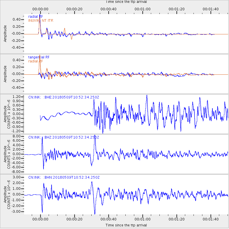
Signal To Noise
| Channel | StoN | STA | LTA |
| CN:INK: :BHZ:20180509T10:52:34.250Z | 45.702595 | 2.7270041E-6 | 5.966847E-8 |
| CN:INK: :BHN:20180509T10:52:34.250Z | 20.220337 | 1.0712378E-6 | 5.2978237E-8 |
| CN:INK: :BHE:20180509T10:52:34.250Z | 2.8496647 | 4.7435935E-7 | 1.6646146E-7 |
| Arrivals |
| Ps | 4.2 SECOND |
| PpPs | 11 SECOND |
| PsPs/PpSs | 15 SECOND |


