You are here: Home > Network List > NM - Cooperative New Madrid Seismic Network Stations List
> Station PENM Penman,Portageville,MO > Earthquake Result Viewer
PENM Penman,Portageville,MO - Earthquake Result Viewer
| Earthquake location: |
Near Coast Of Ecuador |
| Earthquake latitude/longitude: |
0.4/-79.8 |
| Earthquake time(UTC): |
2016/05/18 (139) 07:57:05 GMT |
| Earthquake Depth: |
32 km |
| Earthquake Magnitude: |
6.7 MWP, 6.7 MWW, 6.7 MI |
| Earthquake Catalog/Contributor: |
NEIC PDE/NEIC COMCAT |
|
| Network: |
NM Cooperative New Madrid Seismic Network |
| Station: |
PENM Penman,Portageville,MO |
| Lat/Lon: |
36.45 N/89.63 W |
| Elevation: |
85 m |
|
| Distance: |
37.0 deg |
| Az: |
346.73 deg |
| Baz: |
163.46 deg |
| Ray Param: |
0.07631999 |
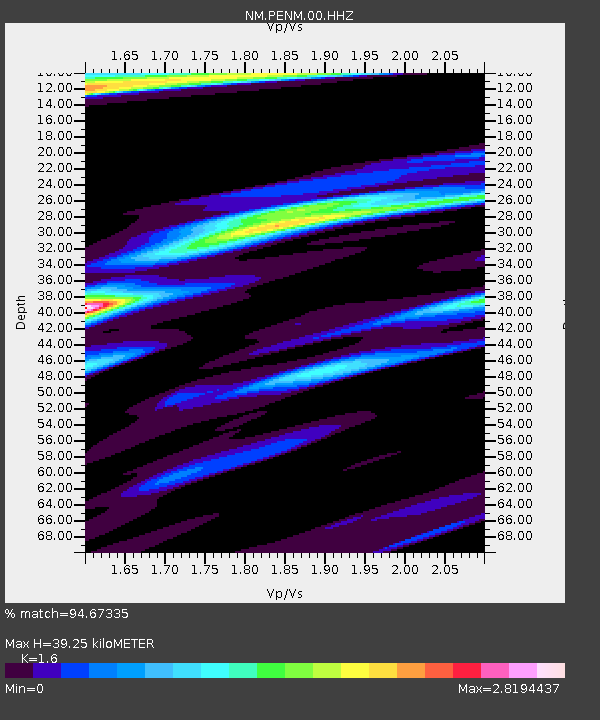
| Estimated Moho Depth: |
39.25 km |
| Estimated Crust Vp/Vs: |
1.60 |
| Assumed Crust Vp: |
6.444 km/s |
| Estimated Crust Vs: |
4.027 km/s |
| Estimated Crust Poisson's Ratio: |
0.18 |
|
| Radial Match: |
94.67335 % |
| Radial Bump: |
331 |
| Transverse Match: |
65.7661 % |
| Transverse Bump: |
400 |
| SOD ConfigId: |
1475611 |
| Insert Time: |
2016-06-01 08:11:41.009 +0000 |
| GWidth: |
2.5 |
| Max Bumps: |
400 |
| Tol: |
0.001 |
|

Signal To Noise
| Channel | StoN | STA | LTA |
| NM:PENM:00:HHZ:20160518T08:03:41.005006Z | 8.037479 | 2.752349E-6 | 3.424393E-7 |
| NM:PENM:00:HHN:20160518T08:03:41.005006Z | 8.6354885 | 5.0305916E-6 | 5.825486E-7 |
| NM:PENM:00:HHE:20160518T08:03:41.005006Z | 3.0902474 | 1.5230444E-6 | 4.928551E-7 |
| Arrivals |
| Ps | 4.0 SECOND |
| PpPs | 15 SECOND |
| PsPs/PpSs | 19 SECOND |


