You are here: Home > Network List > TA - USArray Transportable Network (new EarthScope stations) Stations List
> Station H20A Greybull, WY, USA > Earthquake Result Viewer
H20A Greybull, WY, USA - Earthquake Result Viewer
| Earthquake location: |
Near S. Coast Of Honshu, Japan |
| Earthquake latitude/longitude: |
33.2/137.9 |
| Earthquake time(UTC): |
2009/08/09 (221) 10:55:55 GMT |
| Earthquake Depth: |
297 km |
| Earthquake Magnitude: |
6.5 MB, 7.1 MW, 7.1 MW |
| Earthquake Catalog/Contributor: |
WHDF/NEIC |
|
| Network: |
TA USArray Transportable Network (new EarthScope stations) |
| Station: |
H20A Greybull, WY, USA |
| Lat/Lon: |
44.49 N/108.00 W |
| Elevation: |
1236 m |
|
| Distance: |
82.2 deg |
| Az: |
41.274 deg |
| Baz: |
309.375 deg |
| Ray Param: |
0.046279717 |
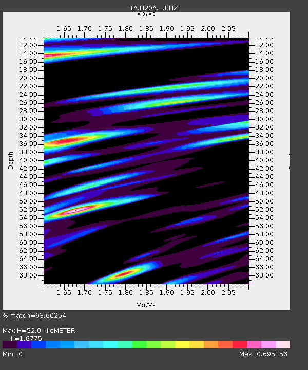
| Estimated Moho Depth: |
52.0 km |
| Estimated Crust Vp/Vs: |
1.68 |
| Assumed Crust Vp: |
6.178 km/s |
| Estimated Crust Vs: |
3.683 km/s |
| Estimated Crust Poisson's Ratio: |
0.22 |
|
| Radial Match: |
93.60254 % |
| Radial Bump: |
400 |
| Transverse Match: |
90.04296 % |
| Transverse Bump: |
400 |
| SOD ConfigId: |
2622 |
| Insert Time: |
2010-03-06 11:04:12.219 +0000 |
| GWidth: |
2.5 |
| Max Bumps: |
400 |
| Tol: |
0.001 |
|
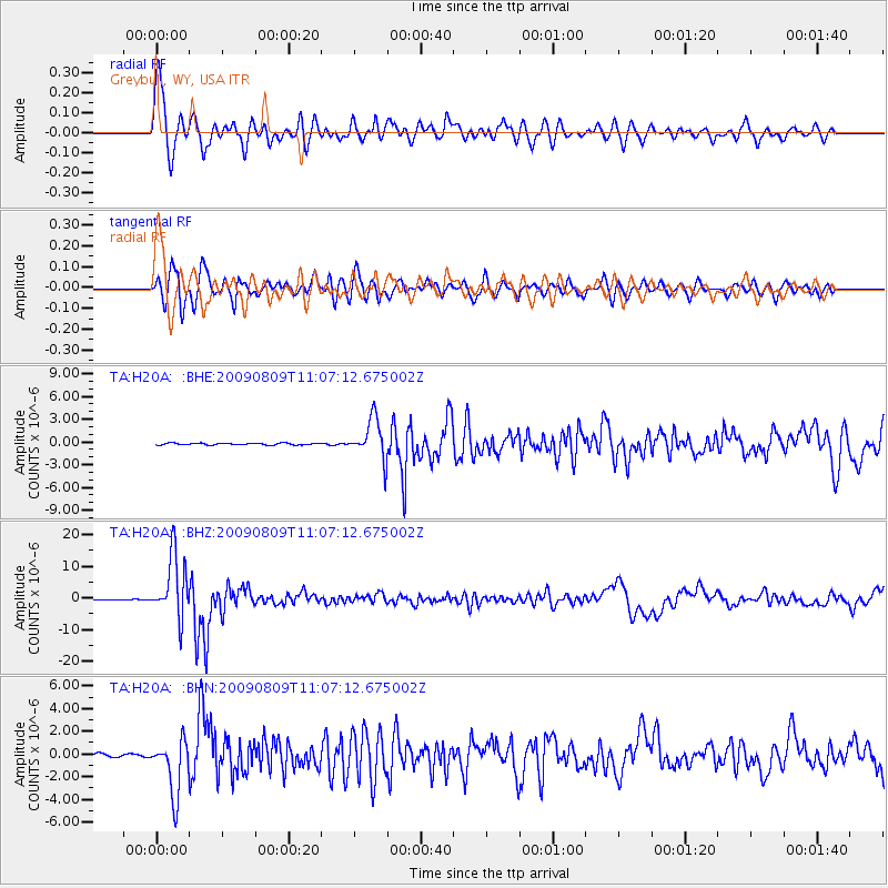
Signal To Noise
| Channel | StoN | STA | LTA |
| TA:H20A: :BHZ:20090809T11:07:12.675002Z | 83.86568 | 9.843372E-6 | 1.1737068E-7 |
| TA:H20A: :BHN:20090809T11:07:12.675002Z | 15.622232 | 2.4141984E-6 | 1.5453607E-7 |
| TA:H20A: :BHE:20090809T11:07:12.675002Z | 22.115194 | 2.6531065E-6 | 1.1996758E-7 |
| Arrivals |
| Ps | 5.8 SECOND |
| PpPs | 22 SECOND |
| PsPs/PpSs | 28 SECOND |


