You are here: Home > Network List > TA - USArray Transportable Network (new EarthScope stations) Stations List
> Station H20A Greybull, WY, USA > Earthquake Result Viewer
H20A Greybull, WY, USA - Earthquake Result Viewer
| Earthquake location: |
Norwegian Sea |
| Earthquake latitude/longitude: |
72.2/0.9 |
| Earthquake time(UTC): |
2009/08/20 (232) 06:35:04 GMT |
| Earthquake Depth: |
6.0 km |
| Earthquake Magnitude: |
5.9 MB, 5.7 MS, 6.0 MW, 6.0 MW |
| Earthquake Catalog/Contributor: |
WHDF/NEIC |
|
| Network: |
TA USArray Transportable Network (new EarthScope stations) |
| Station: |
H20A Greybull, WY, USA |
| Lat/Lon: |
44.49 N/108.00 W |
| Elevation: |
1236 m |
|
| Distance: |
53.6 deg |
| Az: |
302.775 deg |
| Baz: |
21.18 deg |
| Ray Param: |
0.06598294 |
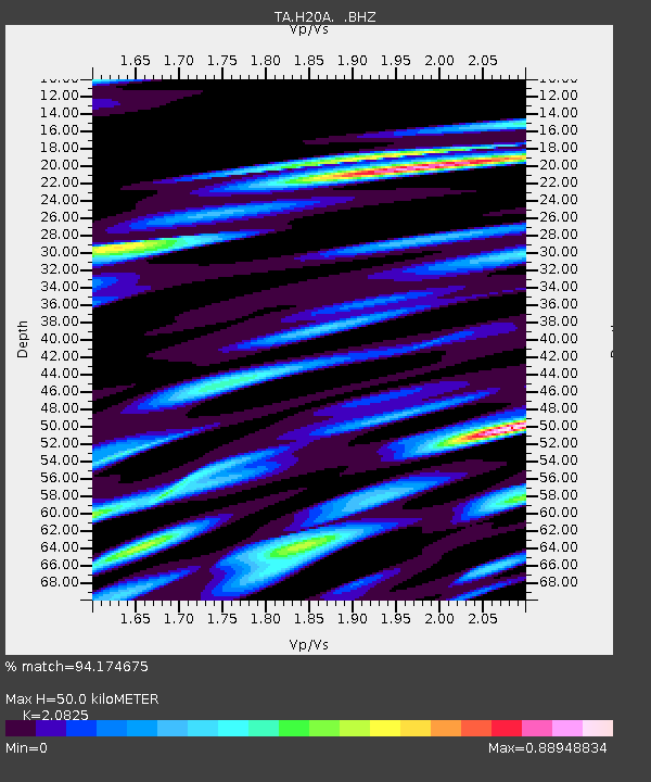
| Estimated Moho Depth: |
50.0 km |
| Estimated Crust Vp/Vs: |
2.08 |
| Assumed Crust Vp: |
6.178 km/s |
| Estimated Crust Vs: |
2.967 km/s |
| Estimated Crust Poisson's Ratio: |
0.35 |
|
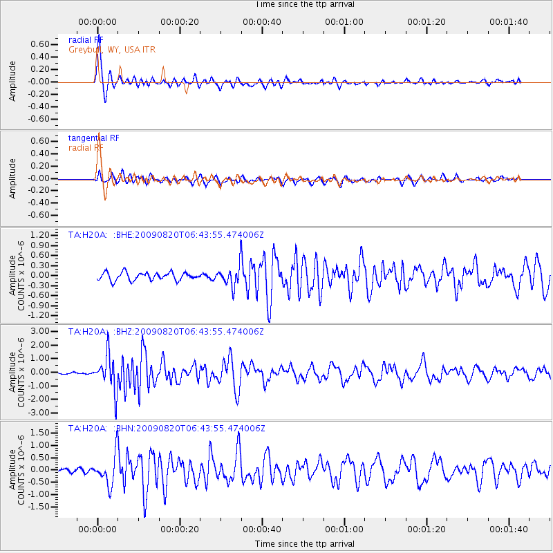
| Radial Match: |
94.174675 % |
| Radial Bump: |
391 |
| Transverse Match: |
77.73181 % |
| Transverse Bump: |
400 |
| SOD ConfigId: |
2622 |
| Insert Time: |
2010-03-06 11:04:19.925 +0000 |
| GWidth: |
2.5 |
| Max Bumps: |
400 |
| Tol: |
0.001 |
|
Signal To Noise
| Channel | StoN | STA | LTA |
| TA:H20A: :BHZ:20090820T06:43:55.474006Z | 17.230984 | 1.3097032E-6 | 7.600861E-8 |
| TA:H20A: :BHN:20090820T06:43:55.474006Z | 8.206526 | 6.35693E-7 | 7.746189E-8 |
| TA:H20A: :BHE:20090820T06:43:55.474006Z | 2.7170544 | 3.2106132E-7 | 1.1816522E-7 |
| Arrivals |
| Ps | 9.1 SECOND |
| PpPs | 24 SECOND |
| PsPs/PpSs | 33 SECOND |


