You are here: Home > Network List > TA - USArray Transportable Network (new EarthScope stations) Stations List
> Station H20A Greybull, WY, USA > Earthquake Result Viewer
H20A Greybull, WY, USA - Earthquake Result Viewer
| Earthquake location: |
Santa Cruz Islands |
| Earthquake latitude/longitude: |
-12.4/166.1 |
| Earthquake time(UTC): |
2009/10/07 (280) 22:50:15 GMT |
| Earthquake Depth: |
21 km |
| Earthquake Magnitude: |
5.8 MB |
| Earthquake Catalog/Contributor: |
WHDF/NEIC |
|
| Network: |
TA USArray Transportable Network (new EarthScope stations) |
| Station: |
H20A Greybull, WY, USA |
| Lat/Lon: |
44.49 N/108.00 W |
| Elevation: |
1236 m |
|
| Distance: |
95.7 deg |
| Az: |
45.846 deg |
| Baz: |
258.335 deg |
| Ray Param: |
0.040710133 |
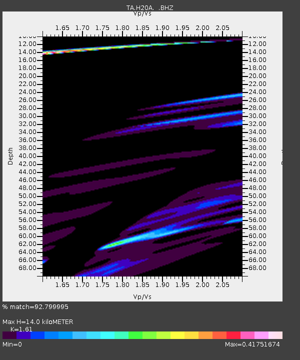
| Estimated Moho Depth: |
14.0 km |
| Estimated Crust Vp/Vs: |
1.61 |
| Assumed Crust Vp: |
6.178 km/s |
| Estimated Crust Vs: |
3.837 km/s |
| Estimated Crust Poisson's Ratio: |
0.19 |
|
| Radial Match: |
92.799995 % |
| Radial Bump: |
400 |
| Transverse Match: |
89.55881 % |
| Transverse Bump: |
345 |
| SOD ConfigId: |
2622 |
| Insert Time: |
2010-03-06 11:04:40.034 +0000 |
| GWidth: |
2.5 |
| Max Bumps: |
400 |
| Tol: |
0.001 |
|
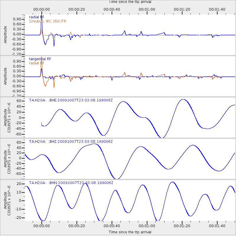
Signal To Noise
| Channel | StoN | STA | LTA |
| TA:H20A: :BHZ:20091007T23:03:08.199006Z | 0.37283468 | 1.1153661E-5 | 2.9915835E-5 |
| TA:H20A: :BHN:20091007T23:03:08.199006Z | 1.4536492 | 2.2232593E-5 | 1.5294332E-5 |
| TA:H20A: :BHE:20091007T23:03:08.199006Z | 2.2599216 | 4.1707463E-5 | 1.845527E-5 |
| Arrivals |
| Ps | 1.4 SECOND |
| PpPs | 5.8 SECOND |
| PsPs/PpSs | 7.2 SECOND |


