You are here: Home > Network List > TA - USArray Transportable Network (new EarthScope stations) Stations List
> Station H20A Greybull, WY, USA > Earthquake Result Viewer
H20A Greybull, WY, USA - Earthquake Result Viewer
| Earthquake location: |
South Of Panama |
| Earthquake latitude/longitude: |
5.7/-82.8 |
| Earthquake time(UTC): |
2009/03/12 (071) 23:23:34 GMT |
| Earthquake Depth: |
9.0 km |
| Earthquake Magnitude: |
6.1 MB, 5.9 MS, 6.3 MW, 6.2 MW |
| Earthquake Catalog/Contributor: |
WHDF/NEIC |
|
| Network: |
TA USArray Transportable Network (new EarthScope stations) |
| Station: |
H20A Greybull, WY, USA |
| Lat/Lon: |
44.49 N/108.00 W |
| Elevation: |
1236 m |
|
| Distance: |
44.5 deg |
| Az: |
334.202 deg |
| Baz: |
142.766 deg |
| Ray Param: |
0.0718712 |
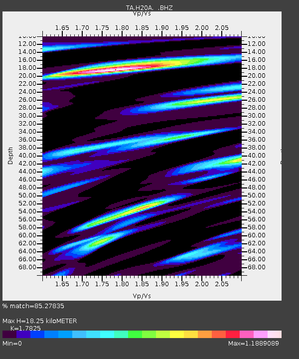
| Estimated Moho Depth: |
18.25 km |
| Estimated Crust Vp/Vs: |
1.78 |
| Assumed Crust Vp: |
6.178 km/s |
| Estimated Crust Vs: |
3.466 km/s |
| Estimated Crust Poisson's Ratio: |
0.27 |
|
| Radial Match: |
85.27835 % |
| Radial Bump: |
400 |
| Transverse Match: |
71.73322 % |
| Transverse Bump: |
400 |
| SOD ConfigId: |
2658 |
| Insert Time: |
2010-03-06 11:04:58.556 +0000 |
| GWidth: |
2.5 |
| Max Bumps: |
400 |
| Tol: |
0.001 |
|
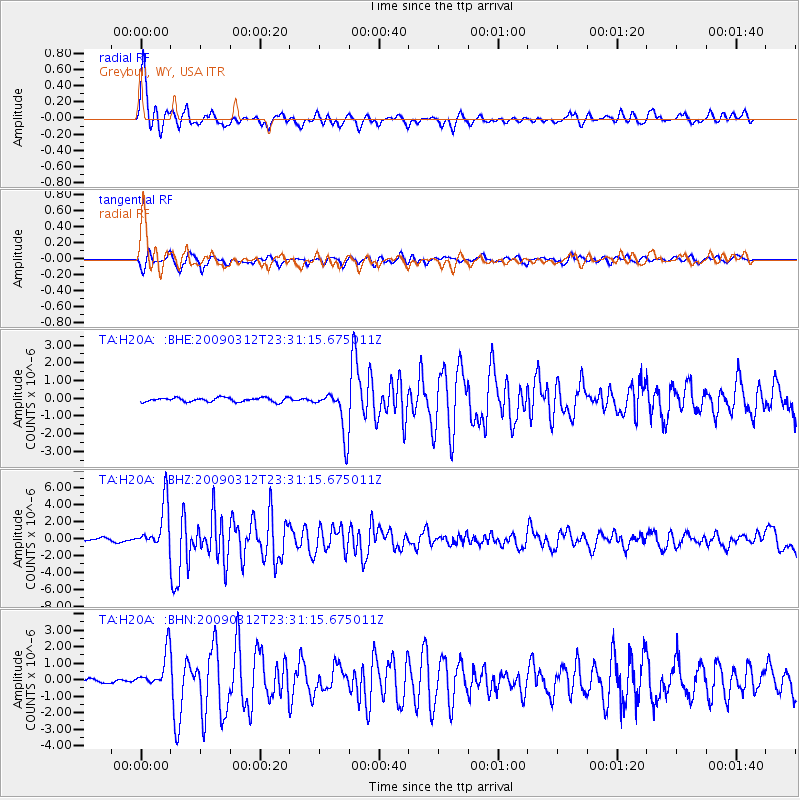
Signal To Noise
| Channel | StoN | STA | LTA |
| TA:H20A: :BHZ:20090312T23:31:15.675011Z | 17.901176 | 2.693528E-6 | 1.5046652E-7 |
| TA:H20A: :BHN:20090312T23:31:15.675011Z | 4.994023 | 1.0949628E-6 | 2.1925466E-7 |
| TA:H20A: :BHE:20090312T23:31:15.675011Z | 10.935152 | 1.2653416E-6 | 1.15713206E-7 |
| Arrivals |
| Ps | 2.5 SECOND |
| PpPs | 7.7 SECOND |
| PsPs/PpSs | 10 SECOND |


