You are here: Home > Network List > TA - USArray Transportable Network (new EarthScope stations) Stations List
> Station H20A Greybull, WY, USA > Earthquake Result Viewer
H20A Greybull, WY, USA - Earthquake Result Viewer
| Earthquake location: |
Panama |
| Earthquake latitude/longitude: |
9.6/-79.0 |
| Earthquake time(UTC): |
2009/07/04 (185) 06:49:35 GMT |
| Earthquake Depth: |
38 km |
| Earthquake Magnitude: |
6.0 MB, 5.5 MS, 6.0 MW, 6.0 MW |
| Earthquake Catalog/Contributor: |
WHDF/NEIC |
|
| Network: |
TA USArray Transportable Network (new EarthScope stations) |
| Station: |
H20A Greybull, WY, USA |
| Lat/Lon: |
44.49 N/108.00 W |
| Elevation: |
1236 m |
|
| Distance: |
42.9 deg |
| Az: |
329.304 deg |
| Baz: |
135.303 deg |
| Ray Param: |
0.072822526 |
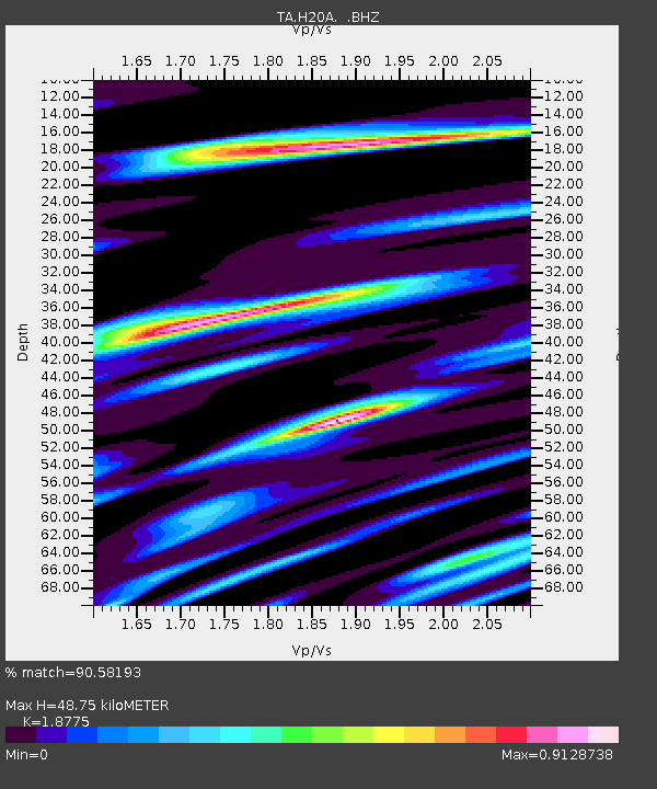
| Estimated Moho Depth: |
48.75 km |
| Estimated Crust Vp/Vs: |
1.88 |
| Assumed Crust Vp: |
6.178 km/s |
| Estimated Crust Vs: |
3.291 km/s |
| Estimated Crust Poisson's Ratio: |
0.30 |
|
| Radial Match: |
90.58193 % |
| Radial Bump: |
400 |
| Transverse Match: |
84.726715 % |
| Transverse Bump: |
400 |
| SOD ConfigId: |
2648 |
| Insert Time: |
2010-03-06 11:05:09.752 +0000 |
| GWidth: |
2.5 |
| Max Bumps: |
400 |
| Tol: |
0.001 |
|
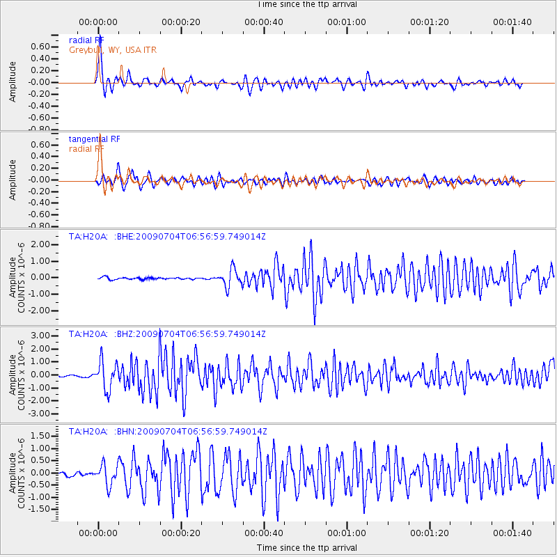
Signal To Noise
| Channel | StoN | STA | LTA |
| TA:H20A: :BHZ:20090704T06:56:59.749014Z | 18.657644 | 1.0976192E-6 | 5.882947E-8 |
| TA:H20A: :BHN:20090704T06:56:59.749014Z | 5.7758894 | 4.2612027E-7 | 7.37757E-8 |
| TA:H20A: :BHE:20090704T06:56:59.749014Z | 9.512222 | 5.5635616E-7 | 5.848856E-8 |
| Arrivals |
| Ps | 7.3 SECOND |
| PpPs | 21 SECOND |
| PsPs/PpSs | 29 SECOND |


