You are here: Home > Network List > TA - USArray Transportable Network (new EarthScope stations) Stations List
> Station H20A Greybull, WY, USA > Earthquake Result Viewer
H20A Greybull, WY, USA - Earthquake Result Viewer
| Earthquake location: |
Off Coast Of Ecuador |
| Earthquake latitude/longitude: |
1.4/-85.2 |
| Earthquake time(UTC): |
2009/05/10 (130) 01:16:06 GMT |
| Earthquake Depth: |
6.0 km |
| Earthquake Magnitude: |
5.5 MB, 5.7 MS, 6.1 MW, 6.1 MW |
| Earthquake Catalog/Contributor: |
WHDF/NEIC |
|
| Network: |
TA USArray Transportable Network (new EarthScope stations) |
| Station: |
H20A Greybull, WY, USA |
| Lat/Lon: |
44.49 N/108.00 W |
| Elevation: |
1236 m |
|
| Distance: |
47.4 deg |
| Az: |
337.85 deg |
| Baz: |
148.223 deg |
| Ray Param: |
0.06999899 |
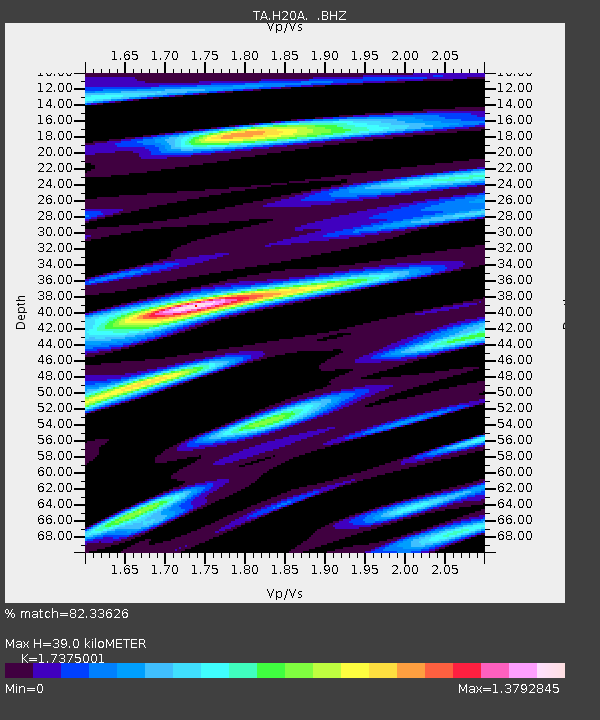
| Estimated Moho Depth: |
39.0 km |
| Estimated Crust Vp/Vs: |
1.74 |
| Assumed Crust Vp: |
6.178 km/s |
| Estimated Crust Vs: |
3.556 km/s |
| Estimated Crust Poisson's Ratio: |
0.25 |
|
| Radial Match: |
82.33626 % |
| Radial Bump: |
400 |
| Transverse Match: |
76.67008 % |
| Transverse Bump: |
400 |
| SOD ConfigId: |
2760 |
| Insert Time: |
2010-03-06 11:05:18.276 +0000 |
| GWidth: |
2.5 |
| Max Bumps: |
400 |
| Tol: |
0.001 |
|
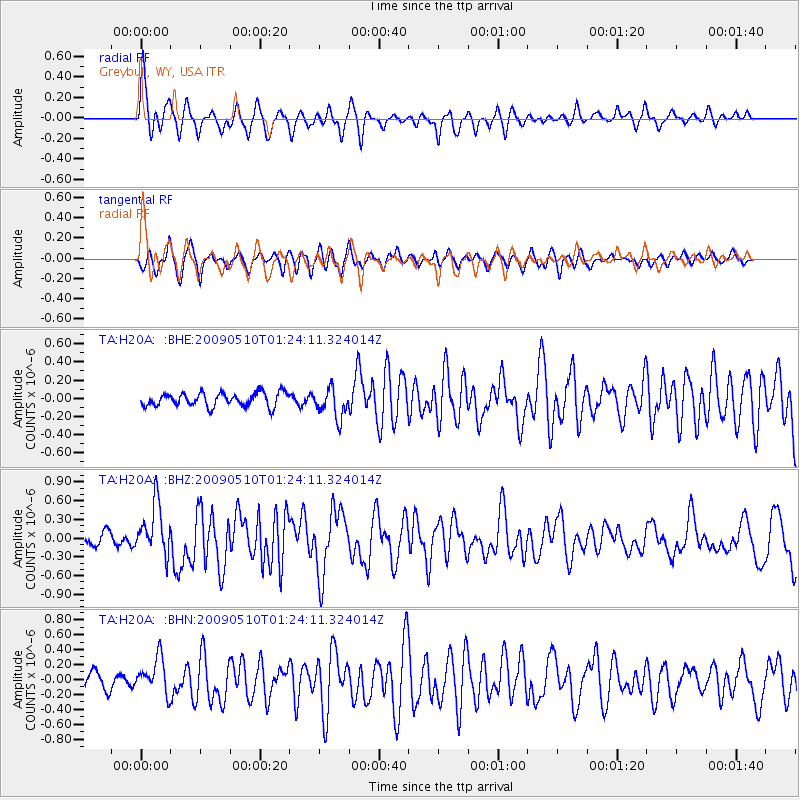
Signal To Noise
| Channel | StoN | STA | LTA |
| TA:H20A: :BHZ:20090510T01:24:11.324014Z | 5.853214 | 4.0683528E-7 | 6.950631E-8 |
| TA:H20A: :BHN:20090510T01:24:11.324014Z | 2.5294895 | 2.4359272E-7 | 9.6301136E-8 |
| TA:H20A: :BHE:20090510T01:24:11.324014Z | 2.1832108 | 1.6203732E-7 | 7.4219734E-8 |
| Arrivals |
| Ps | 4.9 SECOND |
| PpPs | 16 SECOND |
| PsPs/PpSs | 21 SECOND |


