You are here: Home > Network List > TA - USArray Transportable Network (new EarthScope stations) Stations List
> Station H20A Greybull, WY, USA > Earthquake Result Viewer
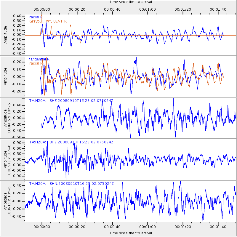
H20A Greybull, WY, USA - Earthquake Result Viewer
*The percent match for this event was below the threshold and hence no stack was calculated.
| Earthquake location: |
Northern Chile |
| Earthquake latitude/longitude: |
-20.3/-69.2 |
| Earthquake time(UTC): |
2008/09/10 (254) 16:12:04 GMT |
| Earthquake Depth: |
38 km |
| Earthquake Magnitude: |
5.6 MB, 5.3 MS |
| Earthquake Catalog/Contributor: |
WHDF/NEIC |
|
| Network: |
TA USArray Transportable Network (new EarthScope stations) |
| Station: |
H20A Greybull, WY, USA |
| Lat/Lon: |
44.49 N/108.00 W |
| Elevation: |
1236 m |
|
| Distance: |
73.5 deg |
| Az: |
332.132 deg |
| Baz: |
142.184 deg |
| Ray Param: |
$rayparam |
*The percent match for this event was below the threshold and hence was not used in the summary stack. |
|
| Radial Match: |
59.529686 % |
| Radial Bump: |
400 |
| Transverse Match: |
49.015934 % |
| Transverse Bump: |
400 |
| SOD ConfigId: |
2560 |
| Insert Time: |
2010-03-06 11:05:30.889 +0000 |
| GWidth: |
2.5 |
| Max Bumps: |
400 |
| Tol: |
0.001 |
|
Signal To Noise
| Channel | StoN | STA | LTA |
| TA:H20A: :BHZ:20080910T16:23:02.075024Z | 2.8104265 | 3.95808E-7 | 1.4083557E-7 |
| TA:H20A: :BHN:20080910T16:23:02.075024Z | 0.67651176 | 1.1518035E-7 | 1.7025623E-7 |
| TA:H20A: :BHE:20080910T16:23:02.075024Z | 1.2863182 | 2.2854789E-7 | 1.7767601E-7 |
| Arrivals |
| Ps | |
| PpPs | |
| PsPs/PpSs | |


