You are here: Home > Network List > TA - USArray Transportable Network (new EarthScope stations) Stations List
> Station D19K Kuna River, AK, USA > Earthquake Result Viewer
D19K Kuna River, AK, USA - Earthquake Result Viewer
| Earthquake location: |
Afghanistan-Tajikistan Bord Reg. |
| Earthquake latitude/longitude: |
37.0/71.4 |
| Earthquake time(UTC): |
2018/05/09 (129) 10:41:45 GMT |
| Earthquake Depth: |
112 km |
| Earthquake Magnitude: |
6.2 Mww |
| Earthquake Catalog/Contributor: |
NEIC PDE/us |
|
| Network: |
TA USArray Transportable Network (new EarthScope stations) |
| Station: |
D19K Kuna River, AK, USA |
| Lat/Lon: |
68.49 N/158.12 W |
| Elevation: |
671 m |
|
| Distance: |
68.6 deg |
| Az: |
17.523 deg |
| Baz: |
319.17 deg |
| Ray Param: |
0.05591724 |
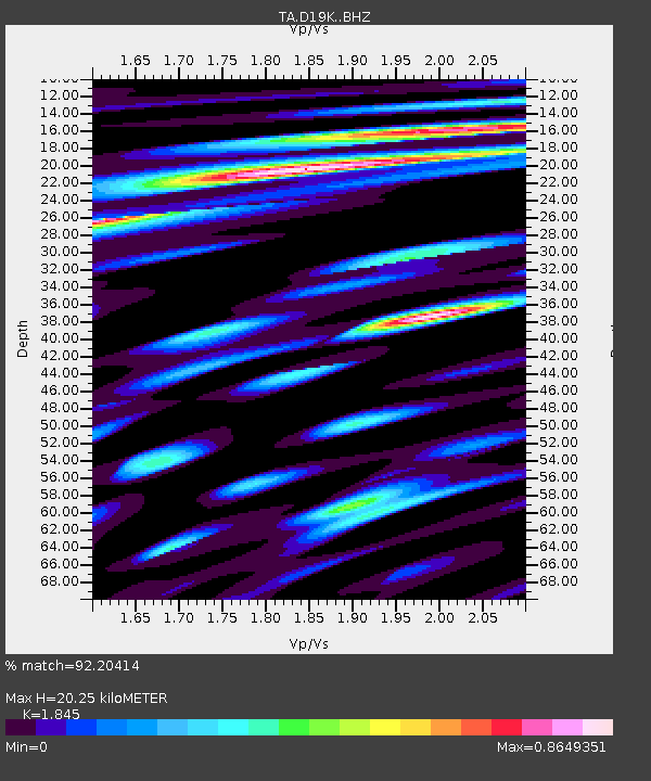
| Estimated Moho Depth: |
20.25 km |
| Estimated Crust Vp/Vs: |
1.85 |
| Assumed Crust Vp: |
6.221 km/s |
| Estimated Crust Vs: |
3.372 km/s |
| Estimated Crust Poisson's Ratio: |
0.29 |
|
| Radial Match: |
92.20414 % |
| Radial Bump: |
400 |
| Transverse Match: |
89.571144 % |
| Transverse Bump: |
400 |
| SOD ConfigId: |
13570011 |
| Insert Time: |
2019-04-30 05:50:40.994 +0000 |
| GWidth: |
2.5 |
| Max Bumps: |
400 |
| Tol: |
0.001 |
|

Signal To Noise
| Channel | StoN | STA | LTA |
| TA:D19K: :BHZ:20180509T10:52:05.424988Z | 22.232378 | 3.334135E-6 | 1.4996753E-7 |
| TA:D19K: :BHN:20180509T10:52:05.424988Z | 9.047992 | 9.368982E-7 | 1.03547634E-7 |
| TA:D19K: :BHE:20180509T10:52:05.424988Z | 7.9326167 | 7.2792045E-7 | 9.176296E-8 |
| Arrivals |
| Ps | 2.8 SECOND |
| PpPs | 8.9 SECOND |
| PsPs/PpSs | 12 SECOND |


