You are here: Home > Network List > TA - USArray Transportable Network (new EarthScope stations) Stations List
> Station G25K Bearman Lake, AK, USA > Earthquake Result Viewer
G25K Bearman Lake, AK, USA - Earthquake Result Viewer
| Earthquake location: |
Afghanistan-Tajikistan Bord Reg. |
| Earthquake latitude/longitude: |
37.0/71.4 |
| Earthquake time(UTC): |
2018/05/09 (129) 10:41:45 GMT |
| Earthquake Depth: |
112 km |
| Earthquake Magnitude: |
6.2 Mww |
| Earthquake Catalog/Contributor: |
NEIC PDE/us |
|
| Network: |
TA USArray Transportable Network (new EarthScope stations) |
| Station: |
G25K Bearman Lake, AK, USA |
| Lat/Lon: |
66.77 N/146.10 W |
| Elevation: |
146 m |
|
| Distance: |
72.7 deg |
| Az: |
14.645 deg |
| Baz: |
329.32 deg |
| Ray Param: |
0.05323298 |
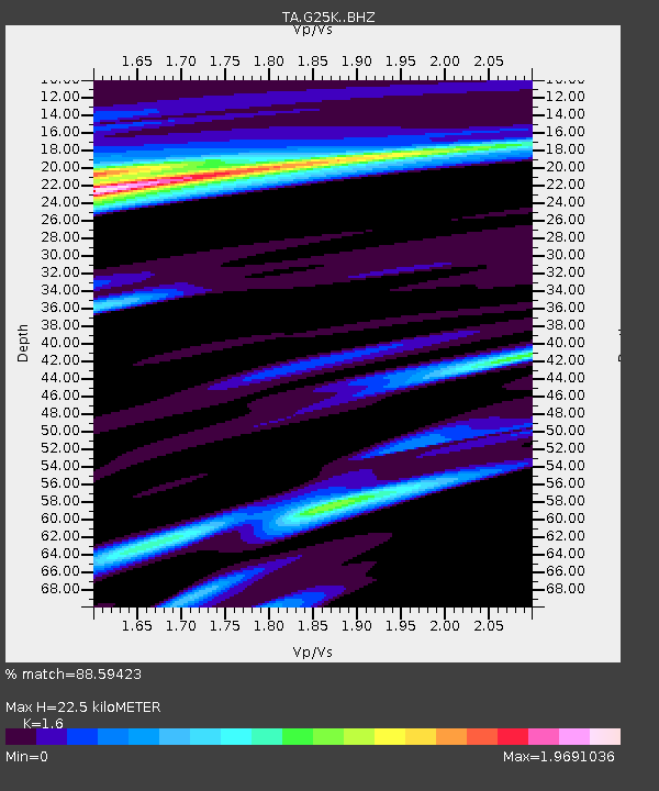
| Estimated Moho Depth: |
22.5 km |
| Estimated Crust Vp/Vs: |
1.60 |
| Assumed Crust Vp: |
6.522 km/s |
| Estimated Crust Vs: |
4.076 km/s |
| Estimated Crust Poisson's Ratio: |
0.18 |
|
| Radial Match: |
88.59423 % |
| Radial Bump: |
367 |
| Transverse Match: |
80.38823 % |
| Transverse Bump: |
400 |
| SOD ConfigId: |
13570011 |
| Insert Time: |
2019-04-30 05:51:14.749 +0000 |
| GWidth: |
2.5 |
| Max Bumps: |
400 |
| Tol: |
0.001 |
|

Signal To Noise
| Channel | StoN | STA | LTA |
| TA:G25K: :BHZ:20180509T10:52:30.150024Z | 14.257643 | 3.9770694E-6 | 2.7894296E-7 |
| TA:G25K: :BHN:20180509T10:52:30.150024Z | 3.6287584 | 1.3838733E-6 | 3.8136275E-7 |
| TA:G25K: :BHE:20180509T10:52:30.150024Z | 4.2859335 | 1.6308496E-6 | 3.805121E-7 |
| Arrivals |
| Ps | 2.2 SECOND |
| PpPs | 8.6 SECOND |
| PsPs/PpSs | 11 SECOND |


