You are here: Home > Network List > TA - USArray Transportable Network (new EarthScope stations) Stations List
> Station H20A Greybull, WY, USA > Earthquake Result Viewer
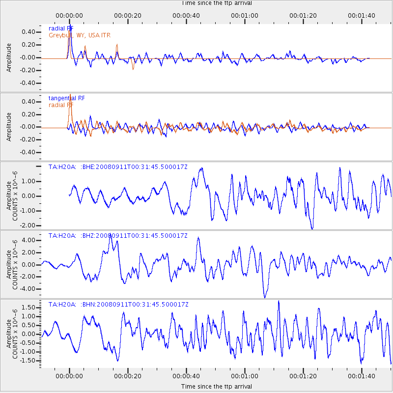
H20A Greybull, WY, USA - Earthquake Result Viewer
*The percent match for this event was below the threshold and hence no stack was calculated.
| Earthquake location: |
Hokkaido, Japan Region |
| Earthquake latitude/longitude: |
41.9/143.8 |
| Earthquake time(UTC): |
2008/09/11 (255) 00:20:50 GMT |
| Earthquake Depth: |
25 km |
| Earthquake Magnitude: |
6.1 MB, 7.0 MS, 6.8 MW, 6.8 MW |
| Earthquake Catalog/Contributor: |
WHDF/NEIC |
|
| Network: |
TA USArray Transportable Network (new EarthScope stations) |
| Station: |
H20A Greybull, WY, USA |
| Lat/Lon: |
44.49 N/108.00 W |
| Elevation: |
1236 m |
|
| Distance: |
72.7 deg |
| Az: |
45.394 deg |
| Baz: |
312.042 deg |
| Ray Param: |
$rayparam |
*The percent match for this event was below the threshold and hence was not used in the summary stack. |
|
| Radial Match: |
78.18056 % |
| Radial Bump: |
400 |
| Transverse Match: |
79.256004 % |
| Transverse Bump: |
400 |
| SOD ConfigId: |
2560 |
| Insert Time: |
2010-03-06 11:05:49.381 +0000 |
| GWidth: |
2.5 |
| Max Bumps: |
400 |
| Tol: |
0.001 |
|
Signal To Noise
| Channel | StoN | STA | LTA |
| TA:H20A: :BHZ:20080911T00:31:45.500017Z | 2.4628377 | 9.050029E-7 | 3.6746346E-7 |
| TA:H20A: :BHN:20080911T00:31:45.500017Z | 1.5209494 | 5.8193865E-7 | 3.826154E-7 |
| TA:H20A: :BHE:20080911T00:31:45.500017Z | 1.5933247 | 5.619904E-7 | 3.5271557E-7 |
| Arrivals |
| Ps | |
| PpPs | |
| PsPs/PpSs | |


