You are here: Home > Network List > US - United States National Seismic Network Stations List
> Station CBKS Cedar Bluff, Kansas, USA > Earthquake Result Viewer
CBKS Cedar Bluff, Kansas, USA - Earthquake Result Viewer
| Earthquake location: |
Near Coast Of Ecuador |
| Earthquake latitude/longitude: |
0.4/-79.8 |
| Earthquake time(UTC): |
2016/05/18 (139) 07:57:05 GMT |
| Earthquake Depth: |
32 km |
| Earthquake Magnitude: |
6.7 MWP, 6.7 MWW, 6.7 MI |
| Earthquake Catalog/Contributor: |
NEIC PDE/NEIC COMCAT |
|
| Network: |
US United States National Seismic Network |
| Station: |
CBKS Cedar Bluff, Kansas, USA |
| Lat/Lon: |
38.81 N/99.74 W |
| Elevation: |
677 m |
|
| Distance: |
42.4 deg |
| Az: |
336.672 deg |
| Baz: |
149.544 deg |
| Ray Param: |
0.07315716 |
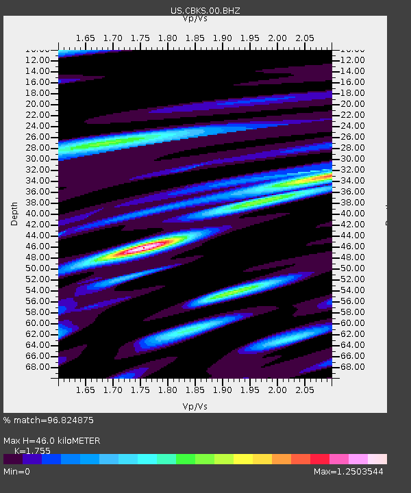
| Estimated Moho Depth: |
46.0 km |
| Estimated Crust Vp/Vs: |
1.75 |
| Assumed Crust Vp: |
6.483 km/s |
| Estimated Crust Vs: |
3.694 km/s |
| Estimated Crust Poisson's Ratio: |
0.26 |
|
| Radial Match: |
96.824875 % |
| Radial Bump: |
373 |
| Transverse Match: |
87.26425 % |
| Transverse Bump: |
400 |
| SOD ConfigId: |
1475611 |
| Insert Time: |
2016-06-01 08:14:36.802 +0000 |
| GWidth: |
2.5 |
| Max Bumps: |
400 |
| Tol: |
0.001 |
|

Signal To Noise
| Channel | StoN | STA | LTA |
| US:CBKS:00:BHZ:20160518T08:04:25.648988Z | 43.13452 | 3.238188E-6 | 7.5071846E-8 |
| US:CBKS:00:BH1:20160518T08:04:25.648988Z | 12.812381 | 2.235384E-6 | 1.7447061E-7 |
| US:CBKS:00:BH2:20160518T08:04:25.648988Z | 7.725377 | 1.2467369E-6 | 1.6138202E-7 |
| Arrivals |
| Ps | 5.7 SECOND |
| PpPs | 18 SECOND |
| PsPs/PpSs | 24 SECOND |


