You are here: Home > Network List > TA - USArray Transportable Network (new EarthScope stations) Stations List
> Station M20K Styx River, AK, USA > Earthquake Result Viewer
M20K Styx River, AK, USA - Earthquake Result Viewer
| Earthquake location: |
Afghanistan-Tajikistan Bord Reg. |
| Earthquake latitude/longitude: |
37.0/71.4 |
| Earthquake time(UTC): |
2018/05/09 (129) 10:41:45 GMT |
| Earthquake Depth: |
112 km |
| Earthquake Magnitude: |
6.2 Mww |
| Earthquake Catalog/Contributor: |
NEIC PDE/us |
|
| Network: |
TA USArray Transportable Network (new EarthScope stations) |
| Station: |
M20K Styx River, AK, USA |
| Lat/Lon: |
61.88 N/153.13 W |
| Elevation: |
1107 m |
|
| Distance: |
75.1 deg |
| Az: |
20.097 deg |
| Baz: |
324.499 deg |
| Ray Param: |
0.051623527 |
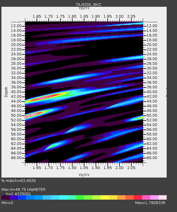
| Estimated Moho Depth: |
49.75 km |
| Estimated Crust Vp/Vs: |
1.62 |
| Assumed Crust Vp: |
6.566 km/s |
| Estimated Crust Vs: |
4.047 km/s |
| Estimated Crust Poisson's Ratio: |
0.19 |
|
| Radial Match: |
83.4828 % |
| Radial Bump: |
400 |
| Transverse Match: |
73.24936 % |
| Transverse Bump: |
400 |
| SOD ConfigId: |
13570011 |
| Insert Time: |
2019-04-30 05:52:05.434 +0000 |
| GWidth: |
2.5 |
| Max Bumps: |
400 |
| Tol: |
0.001 |
|

Signal To Noise
| Channel | StoN | STA | LTA |
| TA:M20K: :BHZ:20180509T10:52:44.250Z | 8.396389 | 1.4215649E-6 | 1.693067E-7 |
| TA:M20K: :BHN:20180509T10:52:44.250Z | 2.451285 | 4.2333846E-7 | 1.7270064E-7 |
| TA:M20K: :BHE:20180509T10:52:44.250Z | 2.0516045 | 3.8756832E-7 | 1.8890985E-7 |
| Arrivals |
| Ps | 4.9 SECOND |
| PpPs | 19 SECOND |
| PsPs/PpSs | 24 SECOND |


