You are here: Home > Network List > TA - USArray Transportable Network (new EarthScope stations) Stations List
> Station H20A Greybull, WY, USA > Earthquake Result Viewer
H20A Greybull, WY, USA - Earthquake Result Viewer
*The percent match for this event was below the threshold and hence no stack was calculated.
| Earthquake location: |
Tonga Islands |
| Earthquake latitude/longitude: |
-20.8/-174.3 |
| Earthquake time(UTC): |
2009/07/30 (211) 20:05:34 GMT |
| Earthquake Depth: |
10 km |
| Earthquake Magnitude: |
5.9 MB, 5.7 MS, 5.8 MW, 5.7 MW |
| Earthquake Catalog/Contributor: |
WHDF/NEIC |
|
| Network: |
TA USArray Transportable Network (new EarthScope stations) |
| Station: |
H20A Greybull, WY, USA |
| Lat/Lon: |
44.49 N/108.00 W |
| Elevation: |
1236 m |
|
| Distance: |
88.7 deg |
| Az: |
40.945 deg |
| Baz: |
238.909 deg |
| Ray Param: |
$rayparam |
*The percent match for this event was below the threshold and hence was not used in the summary stack. |
|
| Radial Match: |
77.73381 % |
| Radial Bump: |
400 |
| Transverse Match: |
68.86891 % |
| Transverse Bump: |
400 |
| SOD ConfigId: |
2622 |
| Insert Time: |
2010-03-06 11:06:04.549 +0000 |
| GWidth: |
2.5 |
| Max Bumps: |
400 |
| Tol: |
0.001 |
|
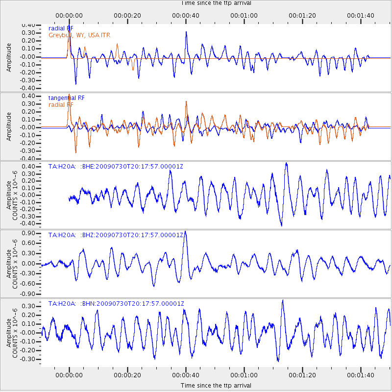
Signal To Noise
| Channel | StoN | STA | LTA |
| TA:H20A: :BHZ:20090730T20:17:57.00001Z | 5.6653595 | 2.6049375E-7 | 4.5980094E-8 |
| TA:H20A: :BHN:20090730T20:17:57.00001Z | 1.108464 | 9.3628806E-8 | 8.446717E-8 |
| TA:H20A: :BHE:20090730T20:17:57.00001Z | 1.78705 | 1.3471706E-7 | 7.538516E-8 |
| Arrivals |
| Ps | |
| PpPs | |
| PsPs/PpSs | |


