You are here: Home > Network List > TA - USArray Transportable Network (new EarthScope stations) Stations List
> Station MDND Maddock, ND, USA > Earthquake Result Viewer
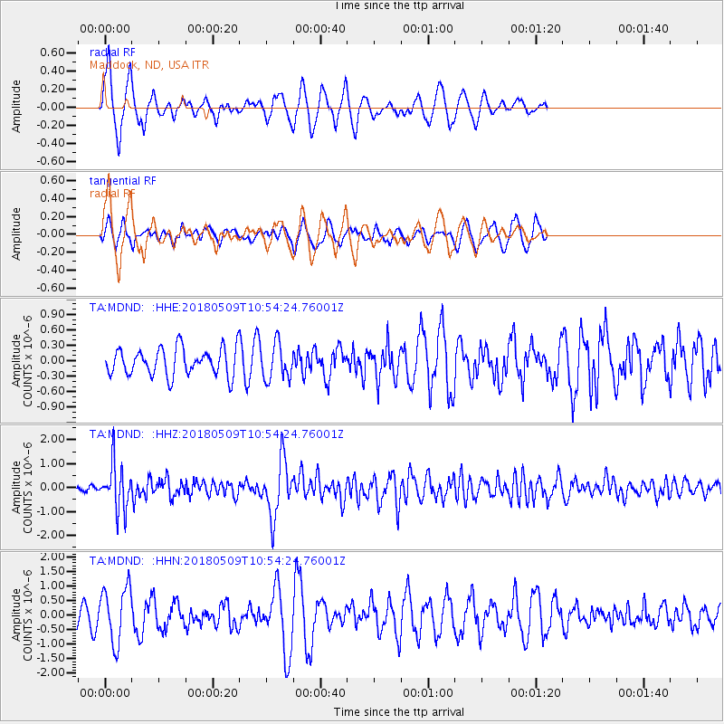
MDND Maddock, ND, USA - Earthquake Result Viewer
*The percent match for this event was below the threshold and hence no stack was calculated.
| Earthquake location: |
Afghanistan-Tajikistan Bord Reg. |
| Earthquake latitude/longitude: |
37.0/71.4 |
| Earthquake time(UTC): |
2018/05/09 (129) 10:41:45 GMT |
| Earthquake Depth: |
112 km |
| Earthquake Magnitude: |
6.2 Mww |
| Earthquake Catalog/Contributor: |
NEIC PDE/us |
|
| Network: |
TA USArray Transportable Network (new EarthScope stations) |
| Station: |
MDND Maddock, ND, USA |
| Lat/Lon: |
47.85 N/99.60 W |
| Elevation: |
479 m |
|
| Distance: |
95.2 deg |
| Az: |
353.908 deg |
| Baz: |
7.247 deg |
| Ray Param: |
$rayparam |
*The percent match for this event was below the threshold and hence was not used in the summary stack. |
|
| Radial Match: |
76.15107 % |
| Radial Bump: |
341 |
| Transverse Match: |
50.399876 % |
| Transverse Bump: |
395 |
| SOD ConfigId: |
13570011 |
| Insert Time: |
2019-04-30 05:52:12.624 +0000 |
| GWidth: |
2.5 |
| Max Bumps: |
400 |
| Tol: |
0.001 |
|
Signal To Noise
| Channel | StoN | STA | LTA |
| TA:MDND: :HHZ:20180509T10:54:24.76001Z | 8.097947 | 9.556533E-7 | 1.180118E-7 |
| TA:MDND: :HHN:20180509T10:54:24.76001Z | 2.2010176 | 9.64442E-7 | 4.3818008E-7 |
| TA:MDND: :HHE:20180509T10:54:24.76001Z | 1.2772927 | 3.499287E-7 | 2.7396126E-7 |
| Arrivals |
| Ps | |
| PpPs | |
| PsPs/PpSs | |


